You are here: Home > Network List > TA - USArray Transportable Network (new EarthScope stations) Stations List
> Station U34A Anderson Ranch, Garber, OK, USA > Earthquake Result Viewer
U34A Anderson Ranch, Garber, OK, USA - Earthquake Result Viewer
| Earthquake location: |
Fox Islands, Aleutian Islands |
| Earthquake latitude/longitude: |
52.0/-171.8 |
| Earthquake time(UTC): |
2011/06/24 (175) 03:09:39 GMT |
| Earthquake Depth: |
52 km |
| Earthquake Magnitude: |
6.9 MB, 7.3 MW, 7.3 MW |
| Earthquake Catalog/Contributor: |
WHDF/NEIC |
|
| Network: |
TA USArray Transportable Network (new EarthScope stations) |
| Station: |
U34A Anderson Ranch, Garber, OK, USA |
| Lat/Lon: |
36.44 N/97.54 W |
| Elevation: |
345 m |
|
| Distance: |
53.1 deg |
| Az: |
76.001 deg |
| Baz: |
312.009 deg |
| Ray Param: |
0.06616611 |
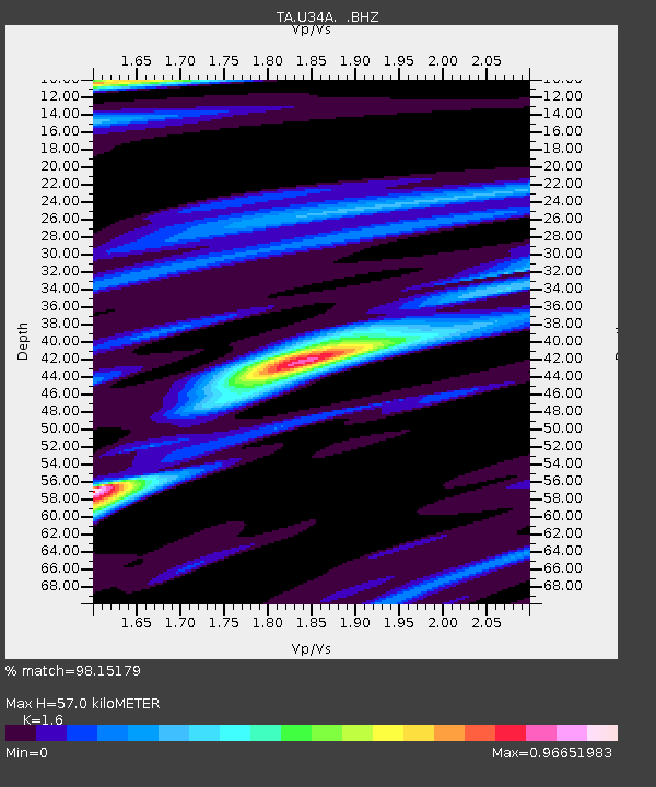
| Estimated Moho Depth: |
57.0 km |
| Estimated Crust Vp/Vs: |
1.60 |
| Assumed Crust Vp: |
6.483 km/s |
| Estimated Crust Vs: |
4.052 km/s |
| Estimated Crust Poisson's Ratio: |
0.18 |
|
| Radial Match: |
98.15179 % |
| Radial Bump: |
289 |
| Transverse Match: |
91.599915 % |
| Transverse Bump: |
400 |
| SOD ConfigId: |
395004 |
| Insert Time: |
2011-12-01 08:12:49.608 +0000 |
| GWidth: |
2.5 |
| Max Bumps: |
400 |
| Tol: |
0.001 |
|
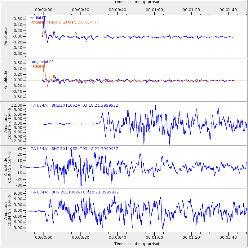
Signal To Noise
| Channel | StoN | STA | LTA |
| TA:U34A: :BHZ:20110624T03:18:21.399993Z | 65.530624 | 8.091628E-6 | 1.2347857E-7 |
| TA:U34A: :BHN:20110624T03:18:21.399993Z | 22.164366 | 3.1817412E-6 | 1.435521E-7 |
| TA:U34A: :BHE:20110624T03:18:21.399993Z | 18.428373 | 3.8441935E-6 | 2.086019E-7 |
| Arrivals |
| Ps | 5.6 SECOND |
| PpPs | 21 SECOND |
| PsPs/PpSs | 27 SECOND |


