You are here: Home > Network List > TA - USArray Transportable Network (new EarthScope stations) Stations List
> Station U33A Lingo Farm, Meno, OK, USA > Earthquake Result Viewer
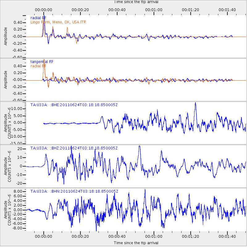
U33A Lingo Farm, Meno, OK, USA - Earthquake Result Viewer
| Earthquake location: |
Fox Islands, Aleutian Islands |
| Earthquake latitude/longitude: |
52.0/-171.8 |
| Earthquake time(UTC): |
2011/06/24 (175) 03:09:39 GMT |
| Earthquake Depth: |
52 km |
| Earthquake Magnitude: |
6.9 MB, 7.3 MW, 7.3 MW |
| Earthquake Catalog/Contributor: |
WHDF/NEIC |
|
| Network: |
TA USArray Transportable Network (new EarthScope stations) |
| Station: |
U33A Lingo Farm, Meno, OK, USA |
| Lat/Lon: |
36.43 N/98.11 W |
| Elevation: |
393 m |
|
| Distance: |
52.8 deg |
| Az: |
76.395 deg |
| Baz: |
311.904 deg |
| Ray Param: |
0.06639627 |
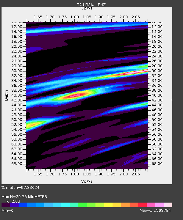
| Estimated Moho Depth: |
29.75 km |
| Estimated Crust Vp/Vs: |
2.08 |
| Assumed Crust Vp: |
6.426 km/s |
| Estimated Crust Vs: |
3.089 km/s |
| Estimated Crust Poisson's Ratio: |
0.35 |
|
| Radial Match: |
97.33024 % |
| Radial Bump: |
379 |
| Transverse Match: |
85.42237 % |
| Transverse Bump: |
400 |
| SOD ConfigId: |
395004 |
| Insert Time: |
2011-12-01 08:13:36.660 +0000 |
| GWidth: |
2.5 |
| Max Bumps: |
400 |
| Tol: |
0.001 |
|
Signal To Noise
| Channel | StoN | STA | LTA |
| TA:U33A: :BHZ:20110624T03:18:18.850005Z | 62.16648 | 7.0350225E-6 | 1.1316423E-7 |
| TA:U33A: :BHN:20110624T03:18:18.850005Z | 11.035193 | 1.970698E-6 | 1.78583E-7 |
| TA:U33A: :BHE:20110624T03:18:18.850005Z | 14.367604 | 2.6010657E-6 | 1.8103684E-7 |
| Arrivals |
| Ps | 5.2 SECOND |
| PpPs | 14 SECOND |
| PsPs/PpSs | 19 SECOND |


