You are here: Home > Network List > TA - USArray Transportable Network (new EarthScope stations) Stations List
> Station W34A Bridge Creek, Tuttle, OK, USA > Earthquake Result Viewer
W34A Bridge Creek, Tuttle, OK, USA - Earthquake Result Viewer

| Earthquake location: |
Fox Islands, Aleutian Islands |
| Earthquake latitude/longitude: |
52.0/-171.8 |
| Earthquake time(UTC): |
2011/06/24 (175) 03:09:39 GMT |
| Earthquake Depth: |
52 km |
| Earthquake Magnitude: |
6.9 MB, 7.3 MW, 7.3 MW |
| Earthquake Catalog/Contributor: |
WHDF/NEIC |
|
| Network: |
TA USArray Transportable Network (new EarthScope stations) |
| Station: |
W34A Bridge Creek, Tuttle, OK, USA |
| Lat/Lon: |
35.24 N/97.77 W |
| Elevation: |
428 m |
|
| Distance: |
53.8 deg |
| Az: |
77.266 deg |
| Baz: |
312.623 deg |
| Ray Param: |
0.065721974 |
| Estimated Moho Depth: |
32.25 km |
| Estimated Crust Vp/Vs: |
2.10 |
| Assumed Crust Vp: |
6.426 km/s |
| Estimated Crust Vs: |
3.064 km/s |
| Estimated Crust Poisson's Ratio: |
0.35 |
|
| Radial Match: |
96.860344 % |
| Radial Bump: |
351 |
| Transverse Match: |
79.86452 % |
| Transverse Bump: |
400 |
| SOD ConfigId: |
395004 |
| Insert Time: |
2011-12-01 08:13:57.502 +0000 |
| GWidth: |
2.5 |
| Max Bumps: |
400 |
| Tol: |
0.001 |
|
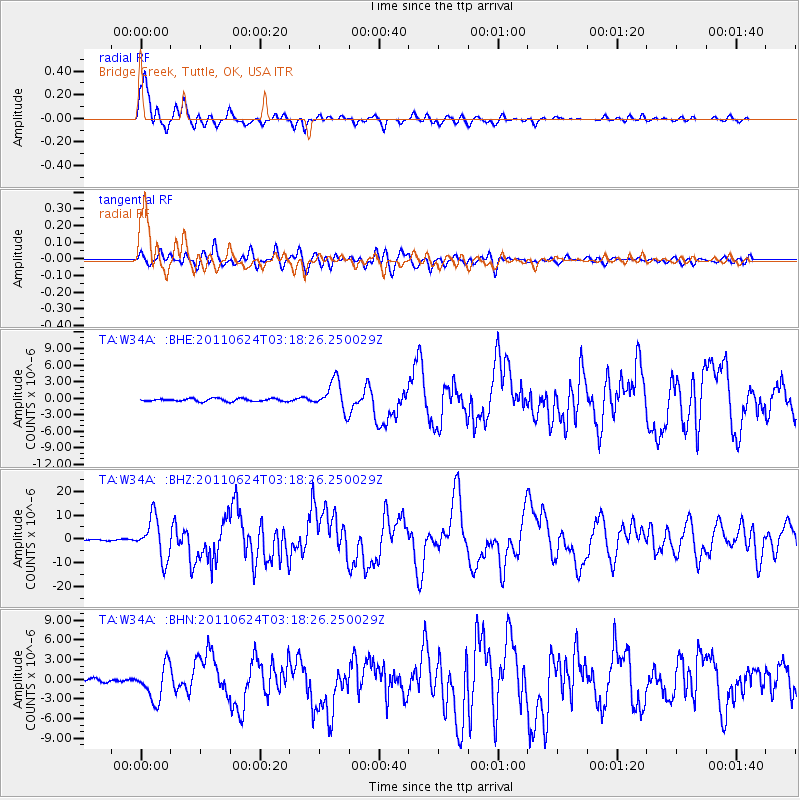
Signal To Noise
| Channel | StoN | STA | LTA |
| TA:W34A: :BHZ:20110624T03:18:26.250029Z | 32.64824 | 8.507605E-6 | 2.605839E-7 |
| TA:W34A: :BHN:20110624T03:18:26.250029Z | 9.598219 | 2.6234254E-6 | 2.733242E-7 |
| TA:W34A: :BHE:20110624T03:18:26.250029Z | 10.752572 | 2.6888085E-6 | 2.500619E-7 |
| Arrivals |
| Ps | 5.8 SECOND |
| PpPs | 15 SECOND |
| PsPs/PpSs | 21 SECOND |


