You are here: Home > Network List > TA - USArray Transportable Network (new EarthScope stations) Stations List
> Station I03D Drain, OR, USA > Earthquake Result Viewer
I03D Drain, OR, USA - Earthquake Result Viewer

| Earthquake location: |
Fox Islands, Aleutian Islands |
| Earthquake latitude/longitude: |
52.0/-171.8 |
| Earthquake time(UTC): |
2011/06/24 (175) 03:09:39 GMT |
| Earthquake Depth: |
52 km |
| Earthquake Magnitude: |
6.9 MB, 7.3 MW, 7.3 MW |
| Earthquake Catalog/Contributor: |
WHDF/NEIC |
|
| Network: |
TA USArray Transportable Network (new EarthScope stations) |
| Station: |
I03D Drain, OR, USA |
| Lat/Lon: |
43.70 N/123.35 W |
| Elevation: |
140 m |
|
| Distance: |
33.0 deg |
| Az: |
85.053 deg |
| Baz: |
301.979 deg |
| Ray Param: |
0.078276694 |
| Estimated Moho Depth: |
53.75 km |
| Estimated Crust Vp/Vs: |
1.67 |
| Assumed Crust Vp: |
6.522 km/s |
| Estimated Crust Vs: |
3.899 km/s |
| Estimated Crust Poisson's Ratio: |
0.22 |
|
| Radial Match: |
84.61202 % |
| Radial Bump: |
348 |
| Transverse Match: |
83.34129 % |
| Transverse Bump: |
400 |
| SOD ConfigId: |
395004 |
| Insert Time: |
2011-12-01 08:20:48.186 +0000 |
| GWidth: |
2.5 |
| Max Bumps: |
400 |
| Tol: |
0.001 |
|
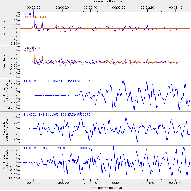
Signal To Noise
| Channel | StoN | STA | LTA |
| TA:I03D: :BHZ:20110624T03:15:39.600005Z | 20.589495 | 4.582374E-6 | 2.2255885E-7 |
| TA:I03D: :BHN:20110624T03:15:39.600005Z | 10.012683 | 1.239913E-6 | 1.2383424E-7 |
| TA:I03D: :BHE:20110624T03:15:39.600005Z | 11.588233 | 1.7385341E-6 | 1.5002583E-7 |
| Arrivals |
| Ps | 6.0 SECOND |
| PpPs | 20 SECOND |
| PsPs/PpSs | 26 SECOND |


