You are here: Home > Network List > CN - Canadian National Seismograph Network Stations List
> Station INK INUVIK, NT > Earthquake Result Viewer
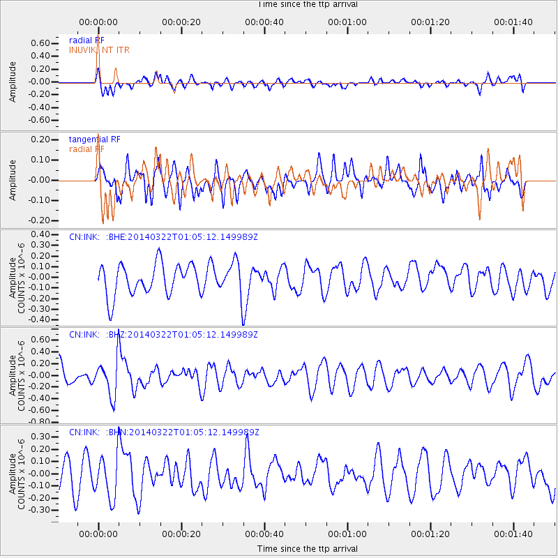
INK INUVIK, NT - Earthquake Result Viewer
*The percent match for this event was below the threshold and hence no stack was calculated.
| Earthquake location: |
Gulf Of California |
| Earthquake latitude/longitude: |
30.4/-114.1 |
| Earthquake time(UTC): |
2014/03/22 (081) 00:58:10 GMT |
| Earthquake Depth: |
1.2 km |
| Earthquake Magnitude: |
5.4 MW |
| Earthquake Catalog/Contributor: |
ISC/ISC |
|
| Network: |
CN Canadian National Seismograph Network |
| Station: |
INK INUVIK, NT |
| Lat/Lon: |
68.31 N/133.53 W |
| Elevation: |
44 m |
|
| Distance: |
39.6 deg |
| Az: |
348.802 deg |
| Baz: |
153.188 deg |
| Ray Param: |
$rayparam |
*The percent match for this event was below the threshold and hence was not used in the summary stack. |
|
| Radial Match: |
39.652664 % |
| Radial Bump: |
382 |
| Transverse Match: |
50.383568 % |
| Transverse Bump: |
400 |
| SOD ConfigId: |
3390531 |
| Insert Time: |
2019-04-10 19:43:01.897 +0000 |
| GWidth: |
2.5 |
| Max Bumps: |
400 |
| Tol: |
0.001 |
|
Signal To Noise
| Channel | StoN | STA | LTA |
| CN:INK: :BHZ:20140322T01:05:12.149989Z | 1.7363873 | 3.2342405E-7 | 1.8626262E-7 |
| CN:INK: :BHN:20140322T01:05:12.149989Z | 1.2806021 | 1.7897797E-7 | 1.397608E-7 |
| CN:INK: :BHE:20140322T01:05:12.149989Z | 1.117695 | 1.6179895E-7 | 1.4476126E-7 |
| Arrivals |
| Ps | |
| PpPs | |
| PsPs/PpSs | |


