You are here: Home > Network List > TA - USArray Transportable Network (new EarthScope stations) Stations List
> Station 134A White-Moore Ranch, Lipan, TX, USA > Earthquake Result Viewer
134A White-Moore Ranch, Lipan, TX, USA - Earthquake Result Viewer
| Earthquake location: |
Fox Islands, Aleutian Islands |
| Earthquake latitude/longitude: |
52.0/-171.8 |
| Earthquake time(UTC): |
2011/06/24 (175) 03:09:39 GMT |
| Earthquake Depth: |
52 km |
| Earthquake Magnitude: |
6.9 MB, 7.3 MW, 7.3 MW |
| Earthquake Catalog/Contributor: |
WHDF/NEIC |
|
| Network: |
TA USArray Transportable Network (new EarthScope stations) |
| Station: |
134A White-Moore Ranch, Lipan, TX, USA |
| Lat/Lon: |
32.57 N/98.08 W |
| Elevation: |
297 m |
|
| Distance: |
55.4 deg |
| Az: |
79.851 deg |
| Baz: |
313.95 deg |
| Ray Param: |
0.06466599 |
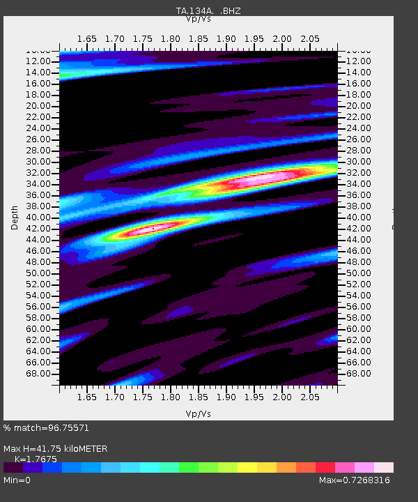
| Estimated Moho Depth: |
41.75 km |
| Estimated Crust Vp/Vs: |
1.77 |
| Assumed Crust Vp: |
6.426 km/s |
| Estimated Crust Vs: |
3.636 km/s |
| Estimated Crust Poisson's Ratio: |
0.26 |
|
| Radial Match: |
96.75571 % |
| Radial Bump: |
388 |
| Transverse Match: |
85.466156 % |
| Transverse Bump: |
400 |
| SOD ConfigId: |
395004 |
| Insert Time: |
2011-12-01 08:23:03.415 +0000 |
| GWidth: |
2.5 |
| Max Bumps: |
400 |
| Tol: |
0.001 |
|
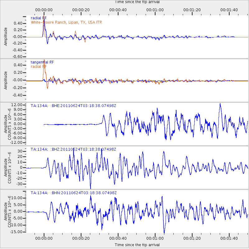
Signal To Noise
| Channel | StoN | STA | LTA |
| TA:134A: :BHZ:20110624T03:18:38.07498Z | 128.02362 | 8.91158E-6 | 6.9608866E-8 |
| TA:134A: :BHN:20110624T03:18:38.07498Z | 35.53976 | 3.4831448E-6 | 9.8006986E-8 |
| TA:134A: :BHE:20110624T03:18:38.07498Z | 50.96405 | 3.563215E-6 | 6.991624E-8 |
| Arrivals |
| Ps | 5.3 SECOND |
| PpPs | 17 SECOND |
| PsPs/PpSs | 22 SECOND |


