You are here: Home > Network List > G - GEOSCOPE Stations List
> Station ATD Arta Cave, Djibouti > Earthquake Result Viewer
ATD Arta Cave, Djibouti - Earthquake Result Viewer
| Earthquake location: |
Hindu Kush Region, Afghanistan |
| Earthquake latitude/longitude: |
36.4/70.9 |
| Earthquake time(UTC): |
1993/08/09 (221) 12:42:49 GMT |
| Earthquake Depth: |
230 km |
| Earthquake Magnitude: |
6.3 MB, 6.9 UNKNOWN |
| Earthquake Catalog/Contributor: |
WHDF/NEIC |
|
| Network: |
G GEOSCOPE |
| Station: |
ATD Arta Cave, Djibouti |
| Lat/Lon: |
11.53 N/42.85 E |
| Elevation: |
610 m |
|
| Distance: |
35.3 deg |
| Az: |
232.71 deg |
| Baz: |
40.938 deg |
| Ray Param: |
0.07640785 |
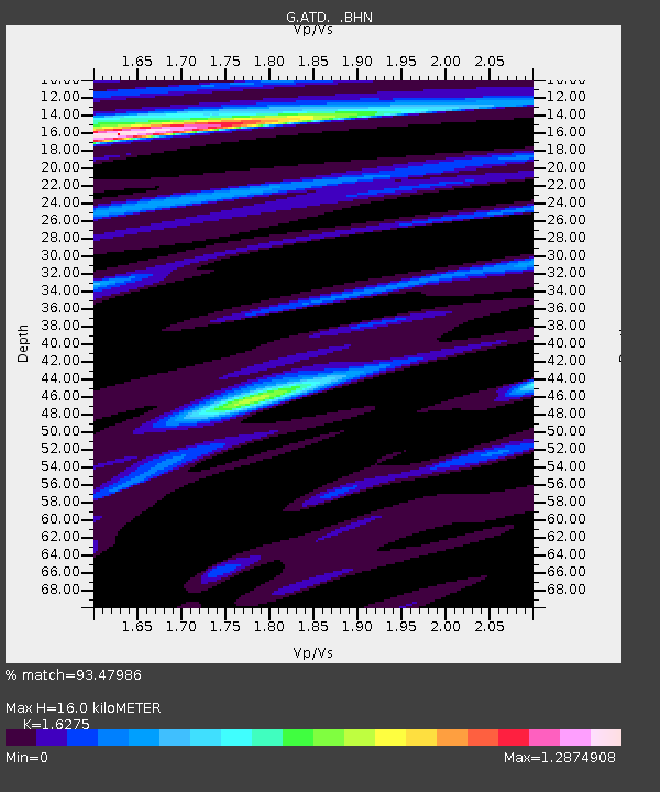
| Estimated Moho Depth: |
16.0 km |
| Estimated Crust Vp/Vs: |
1.63 |
| Assumed Crust Vp: |
6.375 km/s |
| Estimated Crust Vs: |
3.917 km/s |
| Estimated Crust Poisson's Ratio: |
0.20 |
|
| Radial Match: |
93.47986 % |
| Radial Bump: |
278 |
| Transverse Match: |
73.8107 % |
| Transverse Bump: |
400 |
| SOD ConfigId: |
16938 |
| Insert Time: |
2010-02-26 21:26:57.859 +0000 |
| GWidth: |
2.5 |
| Max Bumps: |
400 |
| Tol: |
0.001 |
|
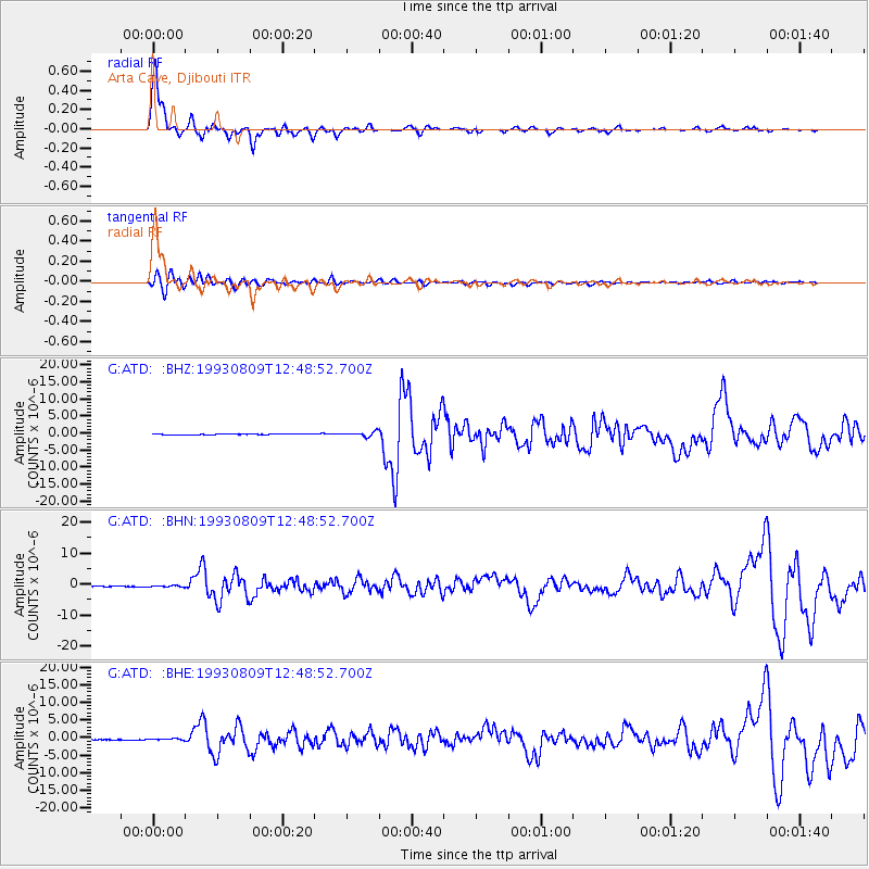
Signal To Noise
| Channel | StoN | STA | LTA |
| G:ATD: :BHN:19930809T12:48:52.700Z | 1.6473017 | 1.9804646E-7 | 1.2022477E-7 |
| G:ATD: :BHE:19930809T12:48:52.700Z | 1.681552 | 1.6984853E-7 | 1.01007004E-7 |
| G:ATD: :BHZ:19930809T12:48:52.700Z | 6.4674134 | 6.58036E-7 | 1.01746394E-7 |
| Arrivals |
| Ps | 1.7 SECOND |
| PpPs | 6.1 SECOND |
| PsPs/PpSs | 7.8 SECOND |


