You are here: Home > Network List > IU - Global Seismograph Network (GSN - IRIS/USGS) Stations List
> Station XMAS Kiritimati Island, Republic of Kiribati > Earthquake Result Viewer
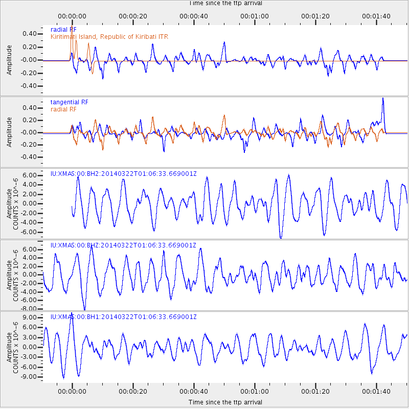
XMAS Kiritimati Island, Republic of Kiribati - Earthquake Result Viewer
*The percent match for this event was below the threshold and hence no stack was calculated.
| Earthquake location: |
Gulf Of California |
| Earthquake latitude/longitude: |
30.4/-114.1 |
| Earthquake time(UTC): |
2014/03/22 (081) 00:58:10 GMT |
| Earthquake Depth: |
1.2 km |
| Earthquake Magnitude: |
5.4 MW |
| Earthquake Catalog/Contributor: |
ISC/ISC |
|
| Network: |
IU Global Seismograph Network (GSN - IRIS/USGS) |
| Station: |
XMAS Kiritimati Island, Republic of Kiribati |
| Lat/Lon: |
2.04 N/157.45 W |
| Elevation: |
20 m |
|
| Distance: |
49.8 deg |
| Az: |
243.922 deg |
| Baz: |
50.91 deg |
| Ray Param: |
$rayparam |
*The percent match for this event was below the threshold and hence was not used in the summary stack. |
|
| Radial Match: |
67.44075 % |
| Radial Bump: |
400 |
| Transverse Match: |
52.00306 % |
| Transverse Bump: |
400 |
| SOD ConfigId: |
3390531 |
| Insert Time: |
2019-04-10 19:43:51.895 +0000 |
| GWidth: |
2.5 |
| Max Bumps: |
400 |
| Tol: |
0.001 |
|
Signal To Noise
| Channel | StoN | STA | LTA |
| IU:XMAS:00:BHZ:20140322T01:06:33.669001Z | 1.0447679 | 4.1015537E-6 | 3.925804E-6 |
| IU:XMAS:00:BH1:20140322T01:06:33.669001Z | 2.4141617 | 5.886509E-6 | 2.4383244E-6 |
| IU:XMAS:00:BH2:20140322T01:06:33.669001Z | 0.66598624 | 1.8476778E-6 | 2.7743486E-6 |
| Arrivals |
| Ps | |
| PpPs | |
| PsPs/PpSs | |


