You are here: Home > Network List > TA - USArray Transportable Network (new EarthScope stations) Stations List
> Station 138A Matatall Enterprise, Big Sandy, TX, USA > Earthquake Result Viewer
138A Matatall Enterprise, Big Sandy, TX, USA - Earthquake Result Viewer
| Earthquake location: |
Fox Islands, Aleutian Islands |
| Earthquake latitude/longitude: |
52.0/-171.8 |
| Earthquake time(UTC): |
2011/06/24 (175) 03:09:39 GMT |
| Earthquake Depth: |
52 km |
| Earthquake Magnitude: |
6.9 MB, 7.3 MW, 7.3 MW |
| Earthquake Catalog/Contributor: |
WHDF/NEIC |
|
| Network: |
TA USArray Transportable Network (new EarthScope stations) |
| Station: |
138A Matatall Enterprise, Big Sandy, TX, USA |
| Lat/Lon: |
32.66 N/95.09 W |
| Elevation: |
143 m |
|
| Distance: |
57.2 deg |
| Az: |
77.663 deg |
| Baz: |
314.341 deg |
| Ray Param: |
0.06352792 |
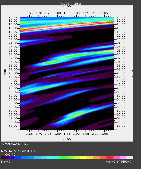
| Estimated Moho Depth: |
15.25 km |
| Estimated Crust Vp/Vs: |
1.79 |
| Assumed Crust Vp: |
6.245 km/s |
| Estimated Crust Vs: |
3.489 km/s |
| Estimated Crust Poisson's Ratio: |
0.27 |
|
| Radial Match: |
96.13721 % |
| Radial Bump: |
355 |
| Transverse Match: |
87.89484 % |
| Transverse Bump: |
400 |
| SOD ConfigId: |
395004 |
| Insert Time: |
2011-12-01 08:27:17.140 +0000 |
| GWidth: |
2.5 |
| Max Bumps: |
400 |
| Tol: |
0.001 |
|
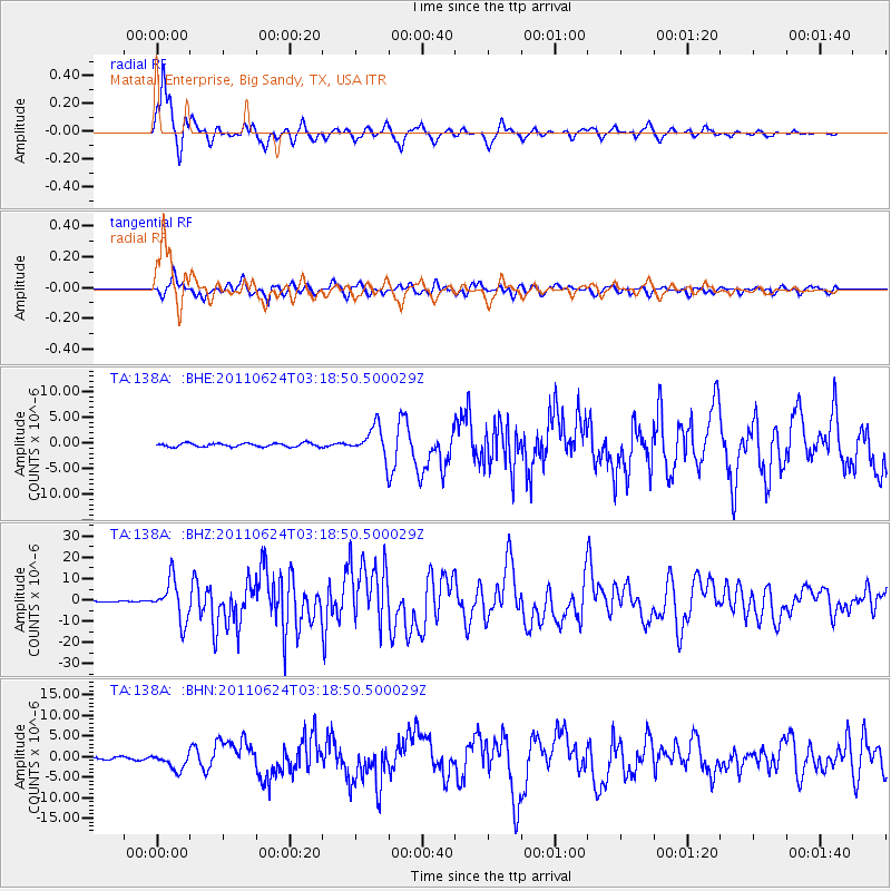
Signal To Noise
| Channel | StoN | STA | LTA |
| TA:138A: :BHZ:20110624T03:18:50.500029Z | 79.03125 | 9.428478E-6 | 1.1930064E-7 |
| TA:138A: :BHN:20110624T03:18:50.500029Z | 8.271913 | 2.0046475E-6 | 2.423439E-7 |
| TA:138A: :BHE:20110624T03:18:50.500029Z | 8.39199 | 2.9153452E-6 | 3.4739617E-7 |
| Arrivals |
| Ps | 2.0 SECOND |
| PpPs | 6.5 SECOND |
| PsPs/PpSs | 8.5 SECOND |


