You are here: Home > Network List > G - GEOSCOPE Stations List
> Station ATD Arta Cave, Djibouti > Earthquake Result Viewer
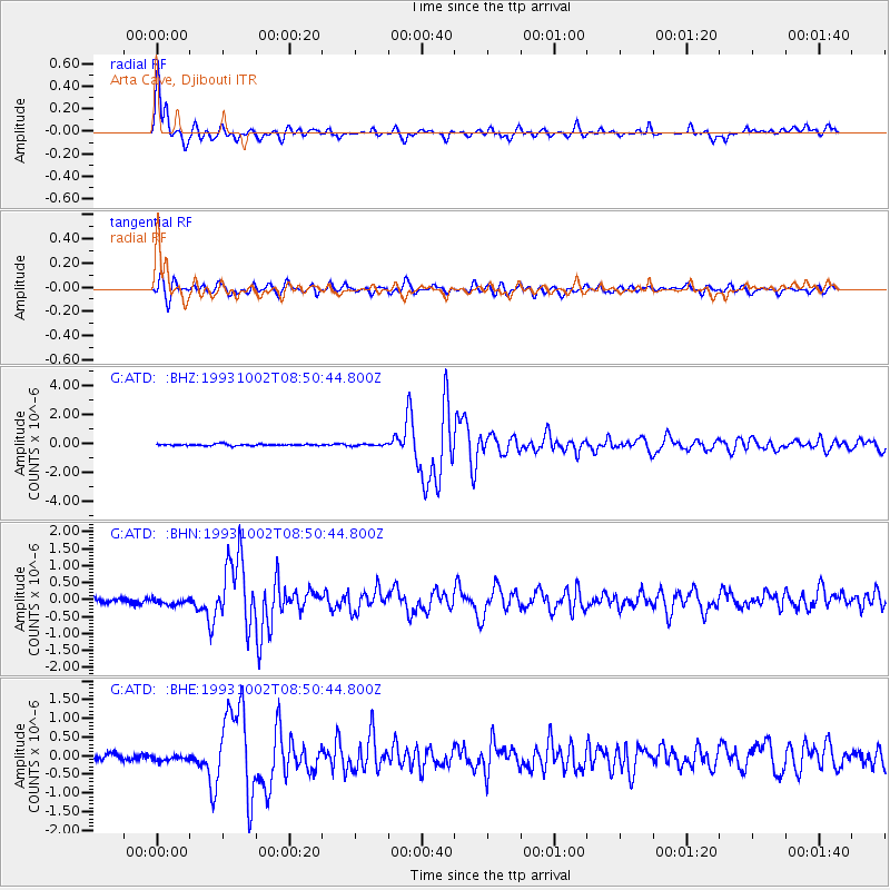
ATD Arta Cave, Djibouti - Earthquake Result Viewer
| Earthquake location: |
Southern Xinjiang, China |
| Earthquake latitude/longitude: |
38.1/88.6 |
| Earthquake time(UTC): |
1993/10/02 (275) 08:42:32 GMT |
| Earthquake Depth: |
16 km |
| Earthquake Magnitude: |
6.2 MB, 6.3 MS, 5.8 UNKNOWN, 6.1 MW |
| Earthquake Catalog/Contributor: |
WHDF/NEIC |
|
| Network: |
G GEOSCOPE |
| Station: |
ATD Arta Cave, Djibouti |
| Lat/Lon: |
11.53 N/42.85 E |
| Elevation: |
610 m |
|
| Distance: |
48.6 deg |
| Az: |
249.425 deg |
| Baz: |
48.869 deg |
| Ray Param: |
0.06922194 |
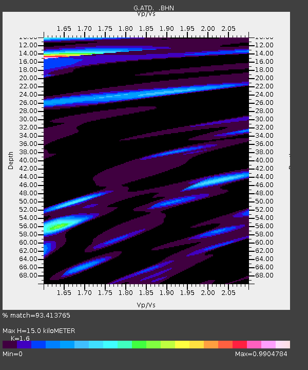
| Estimated Moho Depth: |
15.0 km |
| Estimated Crust Vp/Vs: |
1.60 |
| Assumed Crust Vp: |
6.375 km/s |
| Estimated Crust Vs: |
3.984 km/s |
| Estimated Crust Poisson's Ratio: |
0.18 |
|
| Radial Match: |
93.413765 % |
| Radial Bump: |
377 |
| Transverse Match: |
80.34828 % |
| Transverse Bump: |
400 |
| SOD ConfigId: |
16938 |
| Insert Time: |
2010-02-26 21:27:03.257 +0000 |
| GWidth: |
2.5 |
| Max Bumps: |
400 |
| Tol: |
0.001 |
|
Signal To Noise
| Channel | StoN | STA | LTA |
| G:ATD: :BHN:19931002T08:50:44.800Z | 1.5024049 | 1.6285362E-7 | 1.0839529E-7 |
| G:ATD: :BHE:19931002T08:50:44.800Z | 1.0947313 | 8.239517E-8 | 7.52652E-8 |
| G:ATD: :BHZ:19931002T08:50:44.800Z | 1.0743158 | 6.023735E-8 | 5.607043E-8 |
| Arrivals |
| Ps | 1.5 SECOND |
| PpPs | 5.7 SECOND |
| PsPs/PpSs | 7.2 SECOND |


