You are here: Home > Network List > TA - USArray Transportable Network (new EarthScope stations) Stations List
> Station R37A Teagarden Farms, La Cygne, KS, USA > Earthquake Result Viewer
R37A Teagarden Farms, La Cygne, KS, USA - Earthquake Result Viewer
| Earthquake location: |
Fox Islands, Aleutian Islands |
| Earthquake latitude/longitude: |
52.0/-171.8 |
| Earthquake time(UTC): |
2011/06/24 (175) 03:09:39 GMT |
| Earthquake Depth: |
52 km |
| Earthquake Magnitude: |
6.9 MB, 7.3 MW, 7.3 MW |
| Earthquake Catalog/Contributor: |
WHDF/NEIC |
|
| Network: |
TA USArray Transportable Network (new EarthScope stations) |
| Station: |
R37A Teagarden Farms, La Cygne, KS, USA |
| Lat/Lon: |
38.31 N/94.83 W |
| Elevation: |
298 m |
|
| Distance: |
53.5 deg |
| Az: |
72.468 deg |
| Baz: |
311.534 deg |
| Ray Param: |
0.065925255 |
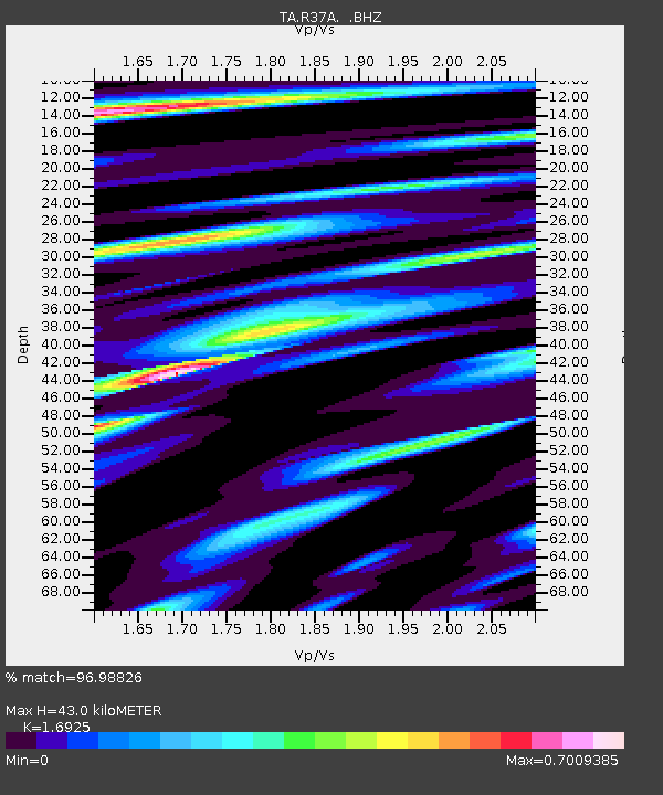
| Estimated Moho Depth: |
43.0 km |
| Estimated Crust Vp/Vs: |
1.69 |
| Assumed Crust Vp: |
6.498 km/s |
| Estimated Crust Vs: |
3.839 km/s |
| Estimated Crust Poisson's Ratio: |
0.23 |
|
| Radial Match: |
96.98826 % |
| Radial Bump: |
400 |
| Transverse Match: |
85.32116 % |
| Transverse Bump: |
400 |
| SOD ConfigId: |
395004 |
| Insert Time: |
2011-12-01 08:27:45.477 +0000 |
| GWidth: |
2.5 |
| Max Bumps: |
400 |
| Tol: |
0.001 |
|

Signal To Noise
| Channel | StoN | STA | LTA |
| TA:R37A: :BHZ:20110624T03:18:24.024993Z | 69.32191 | 7.478148E-6 | 1.0787568E-7 |
| TA:R37A: :BHN:20110624T03:18:24.024993Z | 22.325485 | 3.051262E-6 | 1.366717E-7 |
| TA:R37A: :BHE:20110624T03:18:24.024993Z | 29.718569 | 2.7855283E-6 | 9.373023E-8 |
| Arrivals |
| Ps | 4.9 SECOND |
| PpPs | 17 SECOND |
| PsPs/PpSs | 22 SECOND |


