You are here: Home > Network List > TA - USArray Transportable Network (new EarthScope stations) Stations List
> Station Q37A Longview Farm, Lee's Summit, MO, USA > Earthquake Result Viewer
Q37A Longview Farm, Lee's Summit, MO, USA - Earthquake Result Viewer

| Earthquake location: |
Fox Islands, Aleutian Islands |
| Earthquake latitude/longitude: |
52.0/-171.8 |
| Earthquake time(UTC): |
2011/06/24 (175) 03:09:39 GMT |
| Earthquake Depth: |
52 km |
| Earthquake Magnitude: |
6.9 MB, 7.3 MW, 7.3 MW |
| Earthquake Catalog/Contributor: |
WHDF/NEIC |
|
| Network: |
TA USArray Transportable Network (new EarthScope stations) |
| Station: |
Q37A Longview Farm, Lee's Summit, MO, USA |
| Lat/Lon: |
38.88 N/94.45 W |
| Elevation: |
297 m |
|
| Distance: |
53.3 deg |
| Az: |
71.699 deg |
| Baz: |
311.311 deg |
| Ray Param: |
0.066025764 |
| Estimated Moho Depth: |
43.25 km |
| Estimated Crust Vp/Vs: |
1.82 |
| Assumed Crust Vp: |
6.498 km/s |
| Estimated Crust Vs: |
3.575 km/s |
| Estimated Crust Poisson's Ratio: |
0.28 |
|
| Radial Match: |
97.38828 % |
| Radial Bump: |
400 |
| Transverse Match: |
85.310425 % |
| Transverse Bump: |
400 |
| SOD ConfigId: |
395004 |
| Insert Time: |
2011-12-01 08:27:57.170 +0000 |
| GWidth: |
2.5 |
| Max Bumps: |
400 |
| Tol: |
0.001 |
|
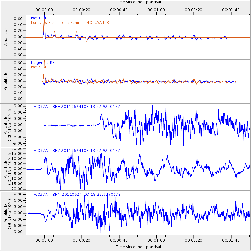
Signal To Noise
| Channel | StoN | STA | LTA |
| TA:Q37A: :BHZ:20110624T03:18:22.925017Z | 40.108776 | 6.258521E-6 | 1.5603868E-7 |
| TA:Q37A: :BHN:20110624T03:18:22.925017Z | 15.212844 | 1.8596124E-6 | 1.2223963E-7 |
| TA:Q37A: :BHE:20110624T03:18:22.925017Z | 16.485981 | 2.4880244E-6 | 1.5091759E-7 |
| Arrivals |
| Ps | 5.7 SECOND |
| PpPs | 18 SECOND |
| PsPs/PpSs | 24 SECOND |


