You are here: Home > Network List > G - GEOSCOPE Stations List
> Station ATD Arta Cave, Djibouti > Earthquake Result Viewer
ATD Arta Cave, Djibouti - Earthquake Result Viewer
| Earthquake location: |
Southeast Of Honshu, Japan |
| Earthquake latitude/longitude: |
32.0/137.9 |
| Earthquake time(UTC): |
1993/10/11 (284) 15:54:22 GMT |
| Earthquake Depth: |
365 km |
| Earthquake Magnitude: |
6.5 MB, 6.8 UNKNOWN, 6.9 MW |
| Earthquake Catalog/Contributor: |
WHDF/NEIC |
|
| Network: |
G GEOSCOPE |
| Station: |
ATD Arta Cave, Djibouti |
| Lat/Lon: |
11.53 N/42.85 E |
| Elevation: |
610 m |
|
| Distance: |
88.2 deg |
| Az: |
282.353 deg |
| Baz: |
57.866 deg |
| Ray Param: |
0.041871905 |
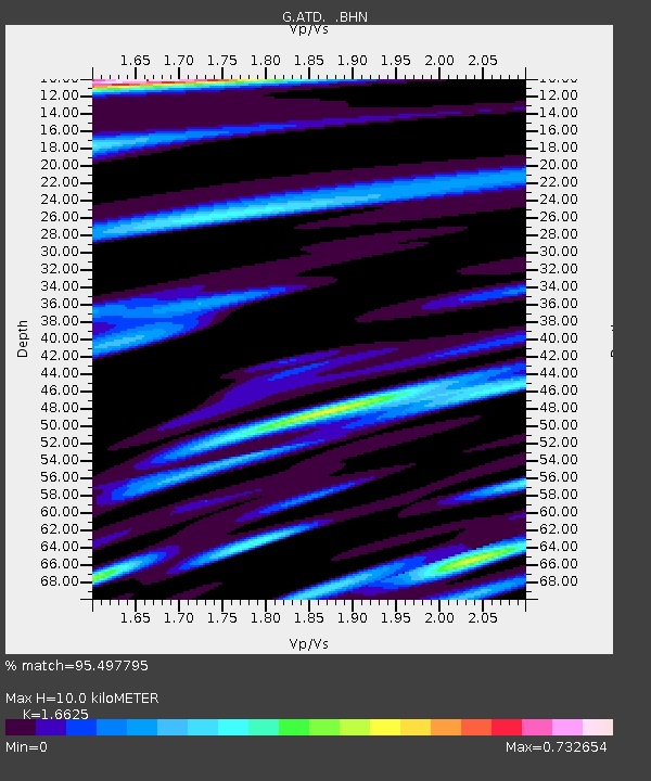
| Estimated Moho Depth: |
10.0 km |
| Estimated Crust Vp/Vs: |
1.66 |
| Assumed Crust Vp: |
6.375 km/s |
| Estimated Crust Vs: |
3.835 km/s |
| Estimated Crust Poisson's Ratio: |
0.22 |
|
| Radial Match: |
95.497795 % |
| Radial Bump: |
400 |
| Transverse Match: |
79.88171 % |
| Transverse Bump: |
400 |
| SOD ConfigId: |
16938 |
| Insert Time: |
2010-02-26 21:27:06.928 +0000 |
| GWidth: |
2.5 |
| Max Bumps: |
400 |
| Tol: |
0.001 |
|
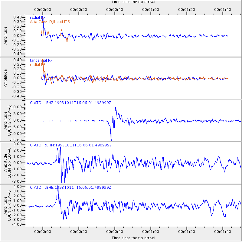
Signal To Noise
| Channel | StoN | STA | LTA |
| G:ATD: :BHN:19931011T16:06:01.498999Z | 1.3506061 | 1.2090679E-7 | 8.95204E-8 |
| G:ATD: :BHE:19931011T16:06:01.498999Z | 0.81857455 | 7.161259E-8 | 8.748451E-8 |
| G:ATD: :BHZ:19931011T16:06:01.498999Z | 1.4070458 | 1.3528691E-7 | 9.614961E-8 |
| Arrivals |
| Ps | 1.1 SECOND |
| PpPs | 4.1 SECOND |
| PsPs/PpSs | 5.1 SECOND |


