You are here: Home > Network List > TA - USArray Transportable Network (new EarthScope stations) Stations List
> Station O36A Bolckow, MO, USA > Earthquake Result Viewer
O36A Bolckow, MO, USA - Earthquake Result Viewer
| Earthquake location: |
Fox Islands, Aleutian Islands |
| Earthquake latitude/longitude: |
52.0/-171.8 |
| Earthquake time(UTC): |
2011/06/24 (175) 03:09:39 GMT |
| Earthquake Depth: |
52 km |
| Earthquake Magnitude: |
6.9 MB, 7.3 MW, 7.3 MW |
| Earthquake Catalog/Contributor: |
WHDF/NEIC |
|
| Network: |
TA USArray Transportable Network (new EarthScope stations) |
| Station: |
O36A Bolckow, MO, USA |
| Lat/Lon: |
40.13 N/94.96 W |
| Elevation: |
306 m |
|
| Distance: |
52.2 deg |
| Az: |
70.835 deg |
| Baz: |
310.464 deg |
| Ray Param: |
0.06676366 |
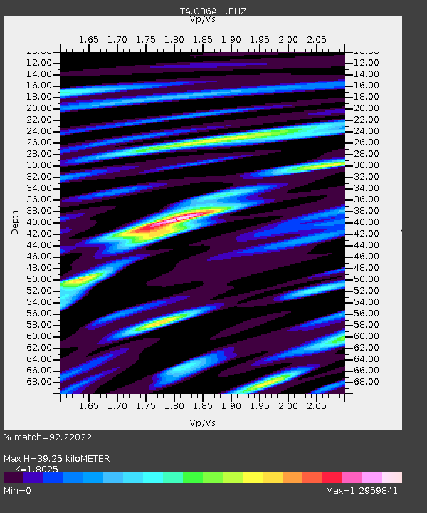
| Estimated Moho Depth: |
39.25 km |
| Estimated Crust Vp/Vs: |
1.80 |
| Assumed Crust Vp: |
6.498 km/s |
| Estimated Crust Vs: |
3.605 km/s |
| Estimated Crust Poisson's Ratio: |
0.28 |
|
| Radial Match: |
92.22022 % |
| Radial Bump: |
400 |
| Transverse Match: |
78.22688 % |
| Transverse Bump: |
400 |
| SOD ConfigId: |
395004 |
| Insert Time: |
2011-12-01 08:31:47.479 +0000 |
| GWidth: |
2.5 |
| Max Bumps: |
400 |
| Tol: |
0.001 |
|
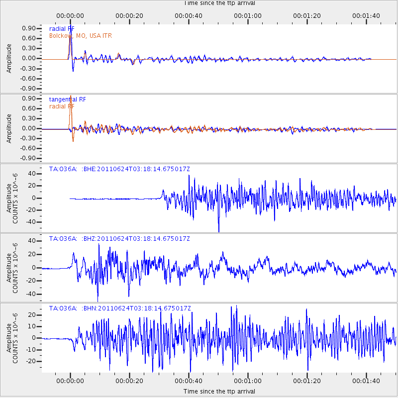
Signal To Noise
| Channel | StoN | STA | LTA |
| TA:O36A: :BHZ:20110624T03:18:14.675017Z | 123.60437 | 1.1139946E-5 | 9.012583E-8 |
| TA:O36A: :BHN:20110624T03:18:14.675017Z | 23.785767 | 4.6648934E-6 | 1.961212E-7 |
| TA:O36A: :BHE:20110624T03:18:14.675017Z | 53.840923 | 6.577857E-6 | 1.2217207E-7 |
| Arrivals |
| Ps | 5.1 SECOND |
| PpPs | 16 SECOND |
| PsPs/PpSs | 21 SECOND |


