You are here: Home > Network List > TA - USArray Transportable Network (new EarthScope stations) Stations List
> Station R35A Emporia Municipal Airport, Emporia, KS, USA > Earthquake Result Viewer
R35A Emporia Municipal Airport, Emporia, KS, USA - Earthquake Result Viewer
| Earthquake location: |
Fox Islands, Aleutian Islands |
| Earthquake latitude/longitude: |
52.0/-171.8 |
| Earthquake time(UTC): |
2011/06/24 (175) 03:09:39 GMT |
| Earthquake Depth: |
52 km |
| Earthquake Magnitude: |
6.9 MB, 7.3 MW, 7.3 MW |
| Earthquake Catalog/Contributor: |
WHDF/NEIC |
|
| Network: |
TA USArray Transportable Network (new EarthScope stations) |
| Station: |
R35A Emporia Municipal Airport, Emporia, KS, USA |
| Lat/Lon: |
38.32 N/96.20 W |
| Elevation: |
365 m |
|
| Distance: |
52.7 deg |
| Az: |
73.349 deg |
| Baz: |
311.218 deg |
| Ray Param: |
0.06647016 |
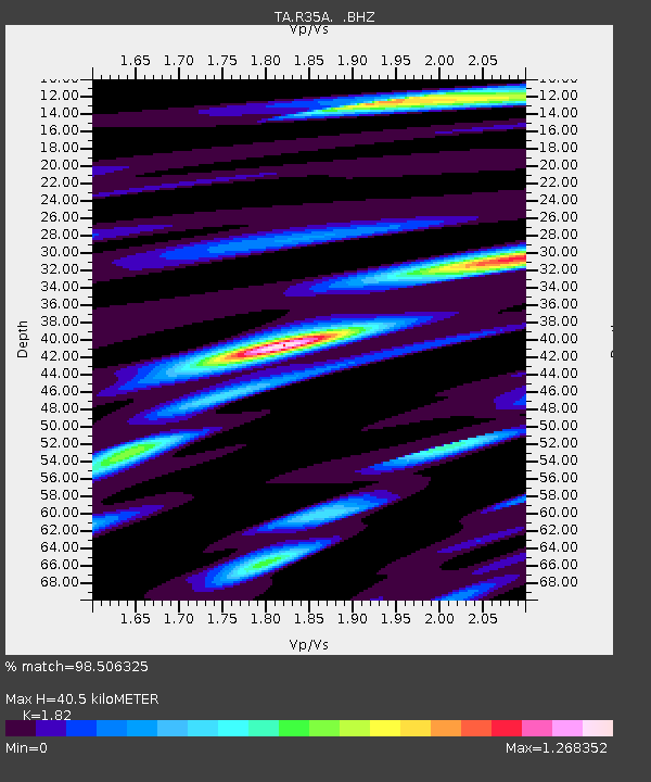
| Estimated Moho Depth: |
40.5 km |
| Estimated Crust Vp/Vs: |
1.82 |
| Assumed Crust Vp: |
6.483 km/s |
| Estimated Crust Vs: |
3.562 km/s |
| Estimated Crust Poisson's Ratio: |
0.28 |
|
| Radial Match: |
98.506325 % |
| Radial Bump: |
270 |
| Transverse Match: |
95.6154 % |
| Transverse Bump: |
400 |
| SOD ConfigId: |
395004 |
| Insert Time: |
2011-12-01 08:31:59.101 +0000 |
| GWidth: |
2.5 |
| Max Bumps: |
400 |
| Tol: |
0.001 |
|

Signal To Noise
| Channel | StoN | STA | LTA |
| TA:R35A: :BHZ:20110624T03:18:18.050017Z | 61.78321 | 9.951961E-6 | 1.6107875E-7 |
| TA:R35A: :BHN:20110624T03:18:18.050017Z | 38.50092 | 4.6199875E-6 | 1.199968E-7 |
| TA:R35A: :BHE:20110624T03:18:18.050017Z | 40.722866 | 4.9355017E-6 | 1.211973E-7 |
| Arrivals |
| Ps | 5.4 SECOND |
| PpPs | 17 SECOND |
| PsPs/PpSs | 22 SECOND |


