You are here: Home > Network List > TA - USArray Transportable Network (new EarthScope stations) Stations List
> Station Z36A Blue Ridge, TX, USA > Earthquake Result Viewer
Z36A Blue Ridge, TX, USA - Earthquake Result Viewer
| Earthquake location: |
Fox Islands, Aleutian Islands |
| Earthquake latitude/longitude: |
52.0/-171.8 |
| Earthquake time(UTC): |
2011/06/24 (175) 03:09:39 GMT |
| Earthquake Depth: |
52 km |
| Earthquake Magnitude: |
6.9 MB, 7.3 MW, 7.3 MW |
| Earthquake Catalog/Contributor: |
WHDF/NEIC |
|
| Network: |
TA USArray Transportable Network (new EarthScope stations) |
| Station: |
Z36A Blue Ridge, TX, USA |
| Lat/Lon: |
33.27 N/96.43 W |
| Elevation: |
187 m |
|
| Distance: |
56.0 deg |
| Az: |
78.083 deg |
| Baz: |
313.844 deg |
| Ray Param: |
0.064331464 |
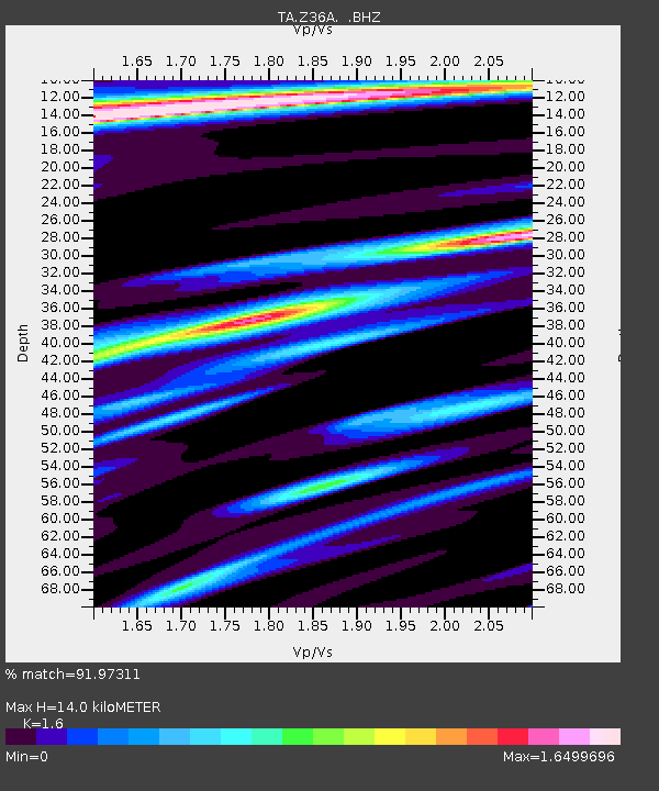
| Estimated Moho Depth: |
14.0 km |
| Estimated Crust Vp/Vs: |
1.60 |
| Assumed Crust Vp: |
6.38 km/s |
| Estimated Crust Vs: |
3.988 km/s |
| Estimated Crust Poisson's Ratio: |
0.18 |
|
| Radial Match: |
91.97311 % |
| Radial Bump: |
400 |
| Transverse Match: |
86.43314 % |
| Transverse Bump: |
400 |
| SOD ConfigId: |
395004 |
| Insert Time: |
2011-12-01 08:33:42.097 +0000 |
| GWidth: |
2.5 |
| Max Bumps: |
400 |
| Tol: |
0.001 |
|
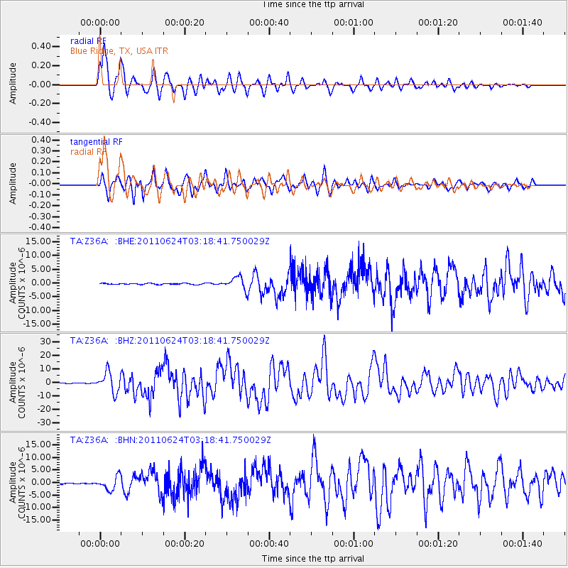
Signal To Noise
| Channel | StoN | STA | LTA |
| TA:Z36A: :BHZ:20110624T03:18:41.750029Z | 79.85773 | 7.698506E-6 | 9.640277E-8 |
| TA:Z36A: :BHN:20110624T03:18:41.750029Z | 11.552141 | 2.7304964E-6 | 2.3636278E-7 |
| TA:Z36A: :BHE:20110624T03:18:41.750029Z | 12.268243 | 2.337209E-6 | 1.9050887E-7 |
| Arrivals |
| Ps | 1.4 SECOND |
| PpPs | 5.4 SECOND |
| PsPs/PpSs | 6.8 SECOND |


