You are here: Home > Network List > TA - USArray Transportable Network (new EarthScope stations) Stations List
> Station N60A Cedar Hill Farm, Mount Bethel, PA, USA > Earthquake Result Viewer
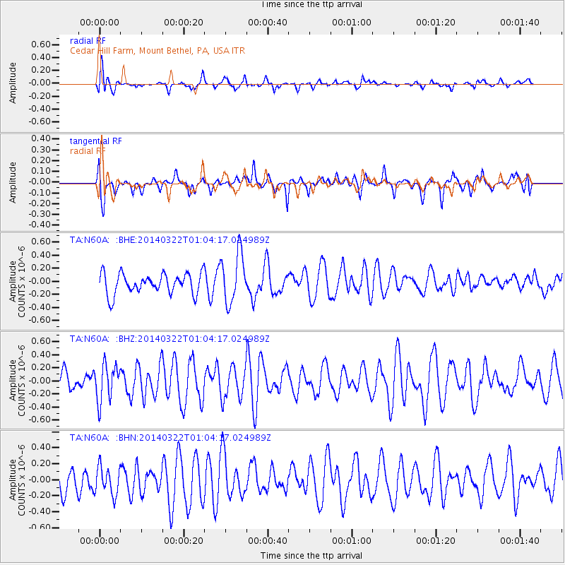
N60A Cedar Hill Farm, Mount Bethel, PA, USA - Earthquake Result Viewer
*The percent match for this event was below the threshold and hence no stack was calculated.
| Earthquake location: |
Gulf Of California |
| Earthquake latitude/longitude: |
30.4/-114.1 |
| Earthquake time(UTC): |
2014/03/22 (081) 00:58:10 GMT |
| Earthquake Depth: |
1.2 km |
| Earthquake Magnitude: |
5.4 MW |
| Earthquake Catalog/Contributor: |
ISC/ISC |
|
| Network: |
TA USArray Transportable Network (new EarthScope stations) |
| Station: |
N60A Cedar Hill Farm, Mount Bethel, PA, USA |
| Lat/Lon: |
40.87 N/75.10 W |
| Elevation: |
189 m |
|
| Distance: |
33.1 deg |
| Az: |
60.888 deg |
| Baz: |
264.205 deg |
| Ray Param: |
$rayparam |
*The percent match for this event was below the threshold and hence was not used in the summary stack. |
|
| Radial Match: |
62.69387 % |
| Radial Bump: |
400 |
| Transverse Match: |
53.817535 % |
| Transverse Bump: |
400 |
| SOD ConfigId: |
3390531 |
| Insert Time: |
2019-04-10 19:45:17.368 +0000 |
| GWidth: |
2.5 |
| Max Bumps: |
400 |
| Tol: |
0.001 |
|
Signal To Noise
| Channel | StoN | STA | LTA |
| TA:N60A: :BHZ:20140322T01:04:17.024989Z | 1.1658746 | 2.871896E-7 | 2.4632976E-7 |
| TA:N60A: :BHN:20140322T01:04:17.024989Z | 0.80549455 | 1.7464139E-7 | 2.1681261E-7 |
| TA:N60A: :BHE:20140322T01:04:17.024989Z | 2.4817524 | 3.8807548E-7 | 1.5637156E-7 |
| Arrivals |
| Ps | |
| PpPs | |
| PsPs/PpSs | |


