You are here: Home > Network List > TA - USArray Transportable Network (new EarthScope stations) Stations List
> Station U37A Salina, OK, USA > Earthquake Result Viewer
U37A Salina, OK, USA - Earthquake Result Viewer

| Earthquake location: |
Fox Islands, Aleutian Islands |
| Earthquake latitude/longitude: |
52.0/-171.8 |
| Earthquake time(UTC): |
2011/06/24 (175) 03:09:39 GMT |
| Earthquake Depth: |
52 km |
| Earthquake Magnitude: |
6.9 MB, 7.3 MW, 7.3 MW |
| Earthquake Catalog/Contributor: |
WHDF/NEIC |
|
| Network: |
TA USArray Transportable Network (new EarthScope stations) |
| Station: |
U37A Salina, OK, USA |
| Lat/Lon: |
36.41 N/95.12 W |
| Elevation: |
248 m |
|
| Distance: |
54.6 deg |
| Az: |
74.404 deg |
| Baz: |
312.498 deg |
| Ray Param: |
0.06521735 |
| Estimated Moho Depth: |
45.75 km |
| Estimated Crust Vp/Vs: |
1.78 |
| Assumed Crust Vp: |
6.53 km/s |
| Estimated Crust Vs: |
3.664 km/s |
| Estimated Crust Poisson's Ratio: |
0.27 |
|
| Radial Match: |
97.943794 % |
| Radial Bump: |
275 |
| Transverse Match: |
84.975426 % |
| Transverse Bump: |
400 |
| SOD ConfigId: |
395004 |
| Insert Time: |
2011-12-01 08:34:51.830 +0000 |
| GWidth: |
2.5 |
| Max Bumps: |
400 |
| Tol: |
0.001 |
|
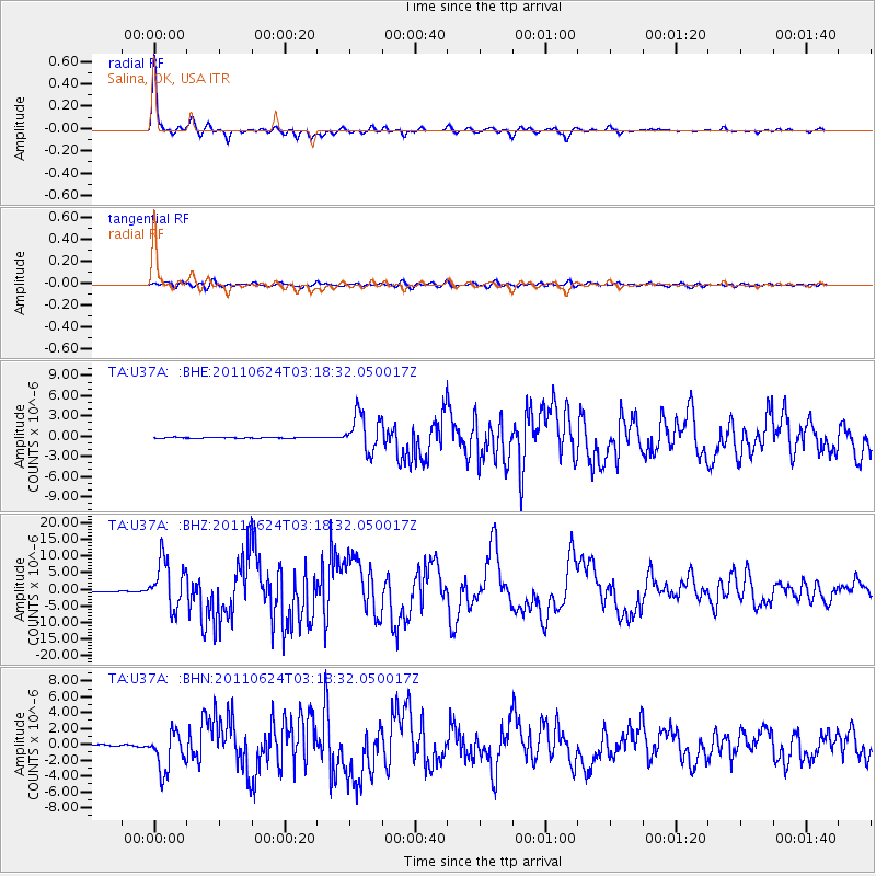
Signal To Noise
| Channel | StoN | STA | LTA |
| TA:U37A: :BHZ:20110624T03:18:32.050017Z | 55.14963 | 7.171577E-6 | 1.3003853E-7 |
| TA:U37A: :BHN:20110624T03:18:32.050017Z | 32.0087 | 2.4767958E-6 | 7.737883E-8 |
| TA:U37A: :BHE:20110624T03:18:32.050017Z | 48.89553 | 2.7589488E-6 | 5.6425375E-8 |
| Arrivals |
| Ps | 5.8 SECOND |
| PpPs | 18 SECOND |
| PsPs/PpSs | 24 SECOND |


