You are here: Home > Network List > TA - USArray Transportable Network (new EarthScope stations) Stations List
> Station J32A Parkston, SD, USA > Earthquake Result Viewer
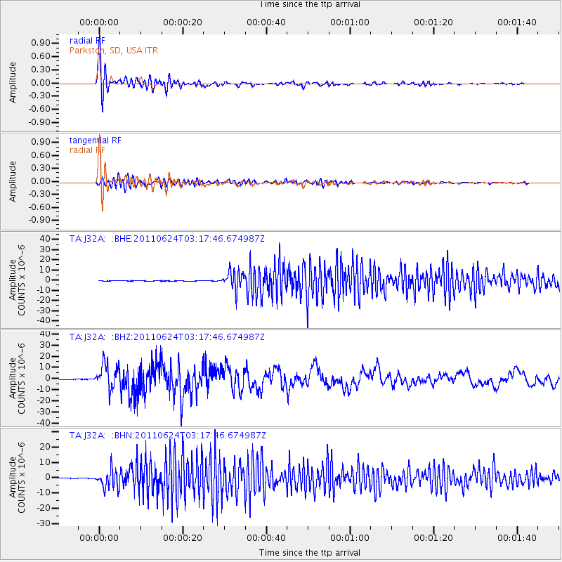
J32A Parkston, SD, USA - Earthquake Result Viewer
| Earthquake location: |
Fox Islands, Aleutian Islands |
| Earthquake latitude/longitude: |
52.0/-171.8 |
| Earthquake time(UTC): |
2011/06/24 (175) 03:09:39 GMT |
| Earthquake Depth: |
52 km |
| Earthquake Magnitude: |
6.9 MB, 7.3 MW, 7.3 MW |
| Earthquake Catalog/Contributor: |
WHDF/NEIC |
|
| Network: |
TA USArray Transportable Network (new EarthScope stations) |
| Station: |
J32A Parkston, SD, USA |
| Lat/Lon: |
43.37 N/97.85 W |
| Elevation: |
399 m |
|
| Distance: |
48.5 deg |
| Az: |
69.335 deg |
| Baz: |
307.592 deg |
| Ray Param: |
0.06916929 |
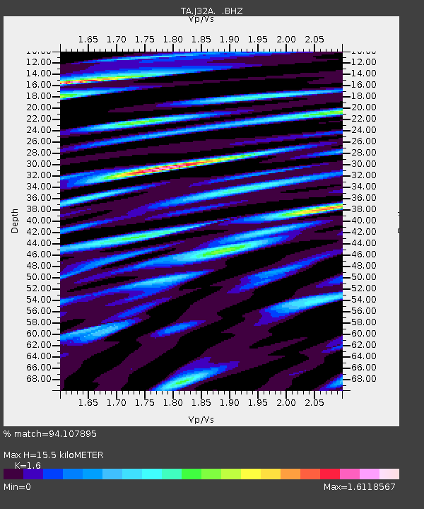
| Estimated Moho Depth: |
15.5 km |
| Estimated Crust Vp/Vs: |
1.60 |
| Assumed Crust Vp: |
6.498 km/s |
| Estimated Crust Vs: |
4.061 km/s |
| Estimated Crust Poisson's Ratio: |
0.18 |
|
| Radial Match: |
94.107895 % |
| Radial Bump: |
400 |
| Transverse Match: |
80.41968 % |
| Transverse Bump: |
400 |
| SOD ConfigId: |
395004 |
| Insert Time: |
2011-12-01 08:35:56.550 +0000 |
| GWidth: |
2.5 |
| Max Bumps: |
400 |
| Tol: |
0.001 |
|
Signal To Noise
| Channel | StoN | STA | LTA |
| TA:J32A: :BHZ:20110624T03:17:46.674987Z | 101.265045 | 1.1014653E-5 | 1.08770536E-7 |
| TA:J32A: :BHN:20110624T03:17:46.674987Z | 58.141743 | 6.0133993E-6 | 1.03426544E-7 |
| TA:J32A: :BHE:20110624T03:17:46.674987Z | 83.554535 | 8.525033E-6 | 1.0202957E-7 |
| Arrivals |
| Ps | 1.5 SECOND |
| PpPs | 5.8 SECOND |
| PsPs/PpSs | 7.3 SECOND |


