You are here: Home > Network List > TA - USArray Transportable Network (new EarthScope stations) Stations List
> Station K35A Storm Lake, IA, USA > Earthquake Result Viewer
K35A Storm Lake, IA, USA - Earthquake Result Viewer
| Earthquake location: |
Fox Islands, Aleutian Islands |
| Earthquake latitude/longitude: |
52.0/-171.8 |
| Earthquake time(UTC): |
2011/06/24 (175) 03:09:39 GMT |
| Earthquake Depth: |
52 km |
| Earthquake Magnitude: |
6.9 MB, 7.3 MW, 7.3 MW |
| Earthquake Catalog/Contributor: |
WHDF/NEIC |
|
| Network: |
TA USArray Transportable Network (new EarthScope stations) |
| Station: |
K35A Storm Lake, IA, USA |
| Lat/Lon: |
42.72 N/95.23 W |
| Elevation: |
439 m |
|
| Distance: |
50.4 deg |
| Az: |
68.447 deg |
| Baz: |
308.794 deg |
| Ray Param: |
0.067927875 |
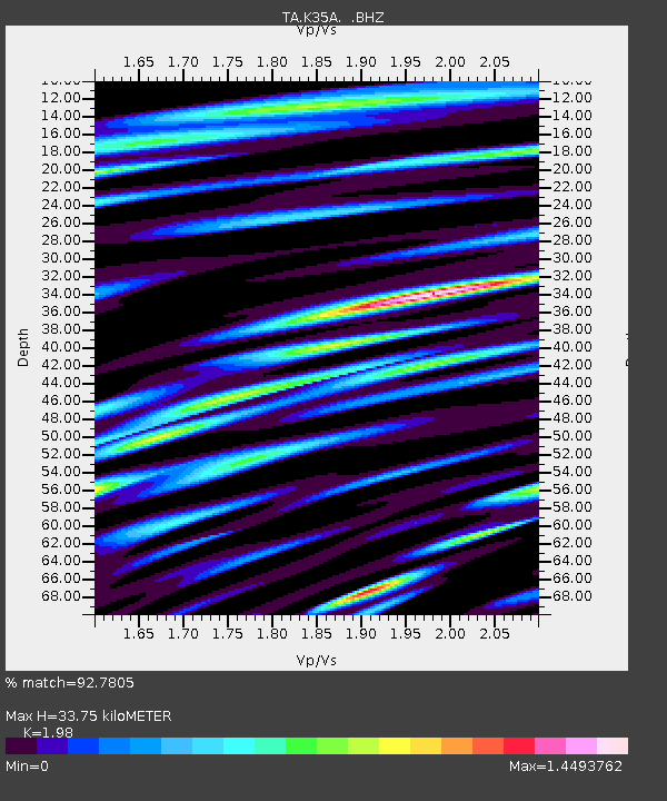
| Estimated Moho Depth: |
33.75 km |
| Estimated Crust Vp/Vs: |
1.98 |
| Assumed Crust Vp: |
6.53 km/s |
| Estimated Crust Vs: |
3.298 km/s |
| Estimated Crust Poisson's Ratio: |
0.33 |
|
| Radial Match: |
92.7805 % |
| Radial Bump: |
400 |
| Transverse Match: |
80.63326 % |
| Transverse Bump: |
400 |
| SOD ConfigId: |
395004 |
| Insert Time: |
2011-12-01 08:36:40.170 +0000 |
| GWidth: |
2.5 |
| Max Bumps: |
400 |
| Tol: |
0.001 |
|
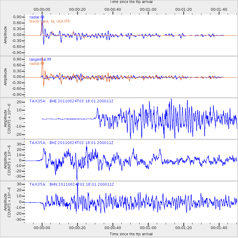
Signal To Noise
| Channel | StoN | STA | LTA |
| TA:K35A: :BHZ:20110624T03:18:01.200011Z | 87.588585 | 1.0637452E-5 | 1.2144793E-7 |
| TA:K35A: :BHN:20110624T03:18:01.200011Z | 40.132484 | 5.1021184E-6 | 1.2713188E-7 |
| TA:K35A: :BHE:20110624T03:18:01.200011Z | 39.741962 | 5.073434E-6 | 1.2765936E-7 |
| Arrivals |
| Ps | 5.3 SECOND |
| PpPs | 15 SECOND |
| PsPs/PpSs | 20 SECOND |


