You are here: Home > Network List > TA - USArray Transportable Network (new EarthScope stations) Stations List
> Station B31A Greenbush Farm, Park River, ND, USA > Earthquake Result Viewer
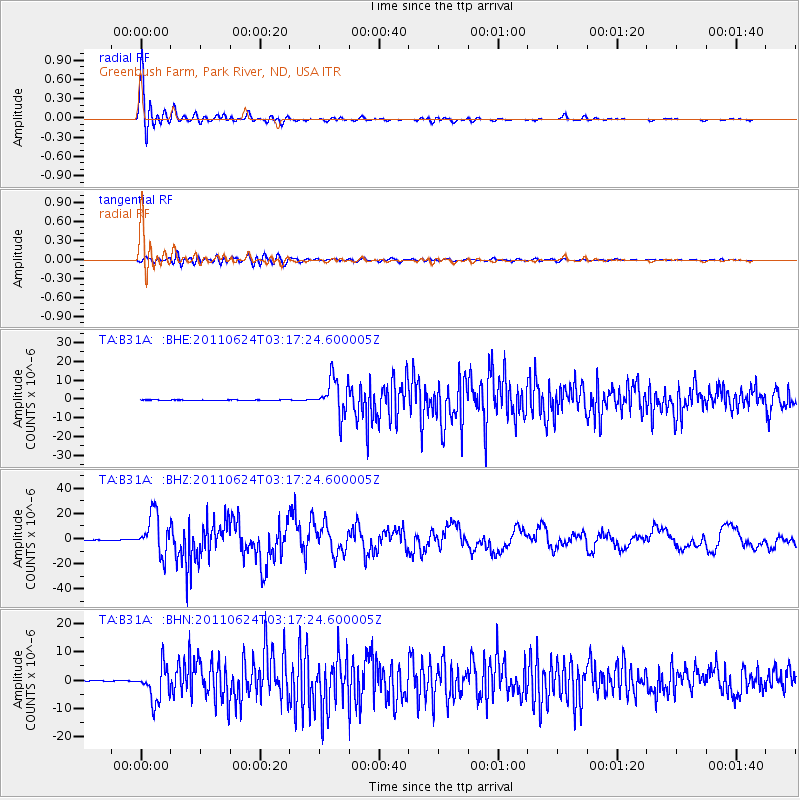
B31A Greenbush Farm, Park River, ND, USA - Earthquake Result Viewer

| Earthquake location: |
Fox Islands, Aleutian Islands |
| Earthquake latitude/longitude: |
52.0/-171.8 |
| Earthquake time(UTC): |
2011/06/24 (175) 03:09:39 GMT |
| Earthquake Depth: |
52 km |
| Earthquake Magnitude: |
6.9 MB, 7.3 MW, 7.3 MW |
| Earthquake Catalog/Contributor: |
WHDF/NEIC |
|
| Network: |
TA USArray Transportable Network (new EarthScope stations) |
| Station: |
B31A Greenbush Farm, Park River, ND, USA |
| Lat/Lon: |
48.42 N/97.65 W |
| Elevation: |
279 m |
|
| Distance: |
45.7 deg |
| Az: |
63.623 deg |
| Baz: |
303.843 deg |
| Ray Param: |
0.07098141 |
| Estimated Moho Depth: |
45.75 km |
| Estimated Crust Vp/Vs: |
1.75 |
| Assumed Crust Vp: |
6.498 km/s |
| Estimated Crust Vs: |
3.713 km/s |
| Estimated Crust Poisson's Ratio: |
0.26 |
|
| Radial Match: |
96.26312 % |
| Radial Bump: |
400 |
| Transverse Match: |
78.47908 % |
| Transverse Bump: |
400 |
| SOD ConfigId: |
395004 |
| Insert Time: |
2011-12-01 08:38:15.892 +0000 |
| GWidth: |
2.5 |
| Max Bumps: |
400 |
| Tol: |
0.001 |
|
Signal To Noise
| Channel | StoN | STA | LTA |
| TA:B31A: :BHZ:20110624T03:17:24.600005Z | 132.37965 | 1.5894491E-5 | 1.2006748E-7 |
| TA:B31A: :BHN:20110624T03:17:24.600005Z | 53.035976 | 6.0848956E-6 | 1.1473147E-7 |
| TA:B31A: :BHE:20110624T03:17:24.600005Z | 81.607864 | 9.611627E-6 | 1.1777819E-7 |
| Arrivals |
| Ps | 5.6 SECOND |
| PpPs | 18 SECOND |
| PsPs/PpSs | 24 SECOND |


