You are here: Home > Network List > TA - USArray Transportable Network (new EarthScope stations) Stations List
> Station H37A Dierke Farm, Cannon Falls, MN, USA > Earthquake Result Viewer
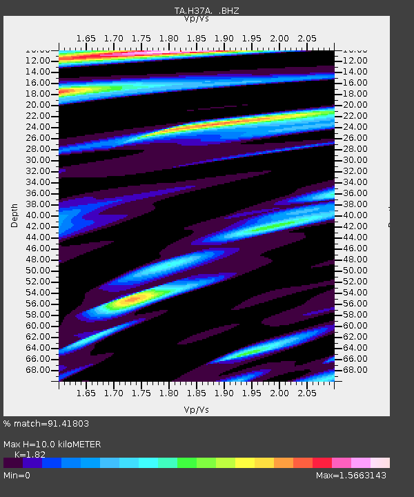
H37A Dierke Farm, Cannon Falls, MN, USA - Earthquake Result Viewer
| Earthquake location: |
Fox Islands, Aleutian Islands |
| Earthquake latitude/longitude: |
52.0/-171.8 |
| Earthquake time(UTC): |
2011/06/24 (175) 03:09:39 GMT |
| Earthquake Depth: |
52 km |
| Earthquake Magnitude: |
6.9 MB, 7.3 MW, 7.3 MW |
| Earthquake Catalog/Contributor: |
WHDF/NEIC |
|
| Network: |
TA USArray Transportable Network (new EarthScope stations) |
| Station: |
H37A Dierke Farm, Cannon Falls, MN, USA |
| Lat/Lon: |
44.58 N/92.92 W |
| Elevation: |
321 m |
|
| Distance: |
50.6 deg |
| Az: |
65.206 deg |
| Baz: |
308.325 deg |
| Ray Param: |
0.067822695 |
| Estimated Moho Depth: |
10.0 km |
| Estimated Crust Vp/Vs: |
1.82 |
| Assumed Crust Vp: |
6.571 km/s |
| Estimated Crust Vs: |
3.61 km/s |
| Estimated Crust Poisson's Ratio: |
0.28 |
|
| Radial Match: |
91.41803 % |
| Radial Bump: |
400 |
| Transverse Match: |
76.125854 % |
| Transverse Bump: |
400 |
| SOD ConfigId: |
395004 |
| Insert Time: |
2011-12-01 08:42:47.036 +0000 |
| GWidth: |
2.5 |
| Max Bumps: |
400 |
| Tol: |
0.001 |
|

Signal To Noise
| Channel | StoN | STA | LTA |
| TA:H37A: :BHZ:20110624T03:18:02.374999Z | 49.621834 | 1.3275979E-5 | 2.675431E-7 |
| TA:H37A: :BHN:20110624T03:18:02.374999Z | 15.979483 | 3.9838555E-6 | 2.4931066E-7 |
| TA:H37A: :BHE:20110624T03:18:02.374999Z | 24.076727 | 4.9629225E-6 | 2.0612944E-7 |
| Arrivals |
| Ps | 1.3 SECOND |
| PpPs | 4.0 SECOND |
| PsPs/PpSs | 5.4 SECOND |


