You are here: Home > Network List > G - GEOSCOPE Stations List
> Station ATD Arta Cave, Djibouti > Earthquake Result Viewer
ATD Arta Cave, Djibouti - Earthquake Result Viewer
| Earthquake location: |
Myanmar |
| Earthquake latitude/longitude: |
20.5/94.2 |
| Earthquake time(UTC): |
1994/05/29 (149) 14:11:51 GMT |
| Earthquake Depth: |
42 km |
| Earthquake Magnitude: |
6.2 MB, 6.2 MS, 5.9 UNKNOWN, 6.5 MW |
| Earthquake Catalog/Contributor: |
WHDF/NEIC |
|
| Network: |
G GEOSCOPE |
| Station: |
ATD Arta Cave, Djibouti |
| Lat/Lon: |
11.53 N/42.85 E |
| Elevation: |
610 m |
|
| Distance: |
49.9 deg |
| Az: |
267.934 deg |
| Baz: |
72.867 deg |
| Ray Param: |
0.06828319 |
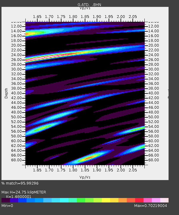
| Estimated Moho Depth: |
24.75 km |
| Estimated Crust Vp/Vs: |
1.68 |
| Assumed Crust Vp: |
6.375 km/s |
| Estimated Crust Vs: |
3.795 km/s |
| Estimated Crust Poisson's Ratio: |
0.23 |
|
| Radial Match: |
95.99296 % |
| Radial Bump: |
400 |
| Transverse Match: |
86.35266 % |
| Transverse Bump: |
400 |
| SOD ConfigId: |
16938 |
| Insert Time: |
2010-02-26 21:27:17.241 +0000 |
| GWidth: |
2.5 |
| Max Bumps: |
400 |
| Tol: |
0.001 |
|
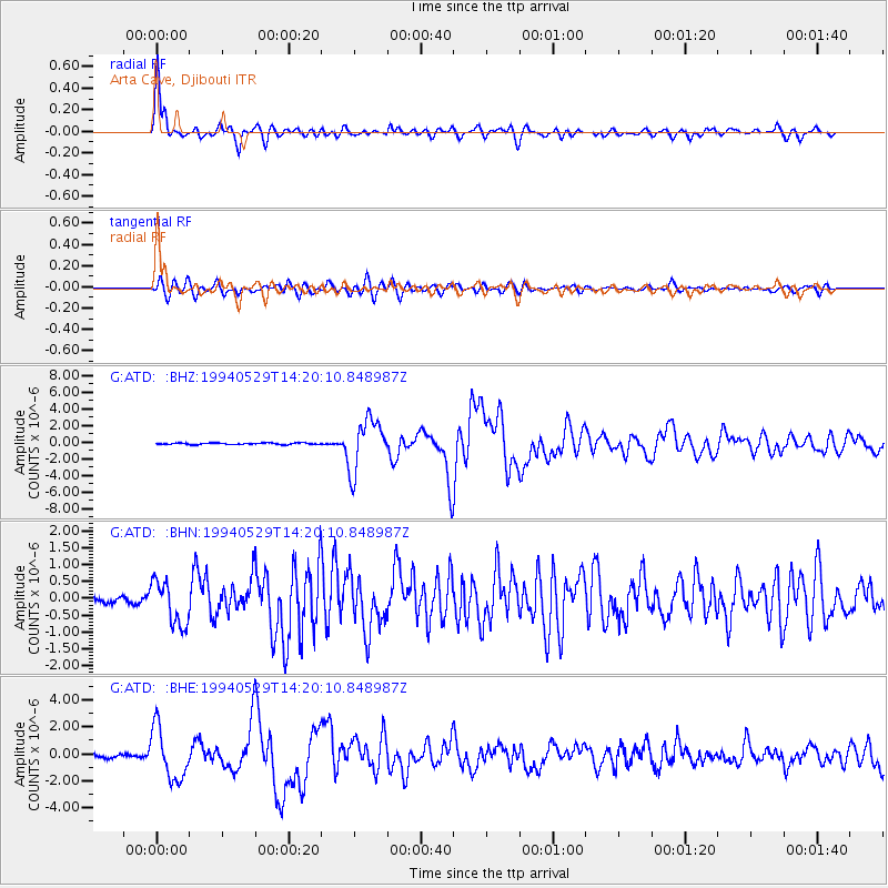
Signal To Noise
| Channel | StoN | STA | LTA |
| G:ATD: :BHN:19940529T14:20:10.848987Z | 5.291779 | 6.672169E-7 | 1.2608557E-7 |
| G:ATD: :BHE:19940529T14:20:10.848987Z | 15.650643 | 1.904268E-6 | 1.2167347E-7 |
| G:ATD: :BHZ:19940529T14:20:10.848987Z | 32.77685 | 3.1000702E-6 | 9.458108E-8 |
| Arrivals |
| Ps | 2.8 SECOND |
| PpPs | 9.8 SECOND |
| PsPs/PpSs | 13 SECOND |


