You are here: Home > Network List > TA - USArray Transportable Network (new EarthScope stations) Stations List
> Station Y40A Okolona, AR, USA > Earthquake Result Viewer
Y40A Okolona, AR, USA - Earthquake Result Viewer

| Earthquake location: |
Fox Islands, Aleutian Islands |
| Earthquake latitude/longitude: |
52.0/-171.8 |
| Earthquake time(UTC): |
2011/06/24 (175) 03:09:39 GMT |
| Earthquake Depth: |
52 km |
| Earthquake Magnitude: |
6.9 MB, 7.3 MW, 7.3 MW |
| Earthquake Catalog/Contributor: |
WHDF/NEIC |
|
| Network: |
TA USArray Transportable Network (new EarthScope stations) |
| Station: |
Y40A Okolona, AR, USA |
| Lat/Lon: |
34.01 N/93.28 W |
| Elevation: |
117 m |
|
| Distance: |
57.3 deg |
| Az: |
75.259 deg |
| Baz: |
314.031 deg |
| Ray Param: |
0.06343502 |
| Estimated Moho Depth: |
10.25 km |
| Estimated Crust Vp/Vs: |
1.76 |
| Assumed Crust Vp: |
6.498 km/s |
| Estimated Crust Vs: |
3.692 km/s |
| Estimated Crust Poisson's Ratio: |
0.26 |
|
| Radial Match: |
96.45416 % |
| Radial Bump: |
400 |
| Transverse Match: |
81.41889 % |
| Transverse Bump: |
400 |
| SOD ConfigId: |
395004 |
| Insert Time: |
2011-12-01 08:48:04.499 +0000 |
| GWidth: |
2.5 |
| Max Bumps: |
400 |
| Tol: |
0.001 |
|
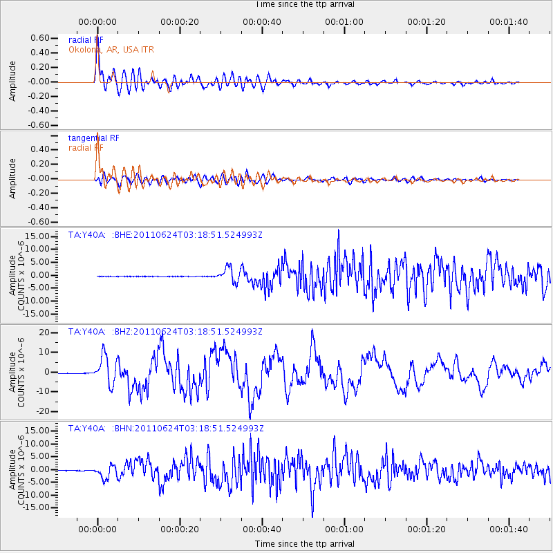
Signal To Noise
| Channel | StoN | STA | LTA |
| TA:Y40A: :BHZ:20110624T03:18:51.524993Z | 68.87525 | 7.426346E-6 | 1.0782314E-7 |
| TA:Y40A: :BHN:20110624T03:18:51.524993Z | 17.581198 | 2.5978647E-6 | 1.477638E-7 |
| TA:Y40A: :BHE:20110624T03:18:51.524993Z | 34.23315 | 2.821558E-6 | 8.24218E-8 |
| Arrivals |
| Ps | 1.3 SECOND |
| PpPs | 4.1 SECOND |
| PsPs/PpSs | 5.4 SECOND |


