You are here: Home > Network List > TA - USArray Transportable Network (new EarthScope stations) Stations List
> Station 240A Hunter Patterson, Mansfield, LA, USA > Earthquake Result Viewer
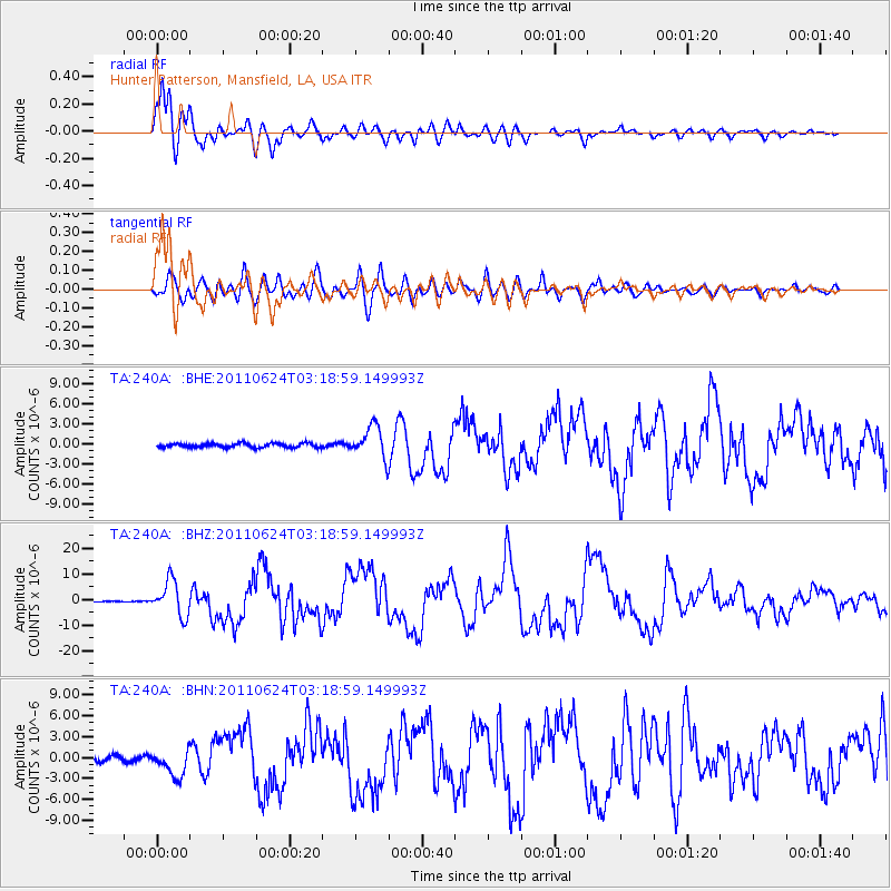
240A Hunter Patterson, Mansfield, LA, USA - Earthquake Result Viewer

| Earthquake location: |
Fox Islands, Aleutian Islands |
| Earthquake latitude/longitude: |
52.0/-171.8 |
| Earthquake time(UTC): |
2011/06/24 (175) 03:09:39 GMT |
| Earthquake Depth: |
52 km |
| Earthquake Magnitude: |
6.9 MB, 7.3 MW, 7.3 MW |
| Earthquake Catalog/Contributor: |
WHDF/NEIC |
|
| Network: |
TA USArray Transportable Network (new EarthScope stations) |
| Station: |
240A Hunter Patterson, Mansfield, LA, USA |
| Lat/Lon: |
32.04 N/93.76 W |
| Elevation: |
119 m |
|
| Distance: |
58.4 deg |
| Az: |
77.253 deg |
| Baz: |
314.829 deg |
| Ray Param: |
0.06273159 |
| Estimated Moho Depth: |
10.75 km |
| Estimated Crust Vp/Vs: |
2.09 |
| Assumed Crust Vp: |
6.245 km/s |
| Estimated Crust Vs: |
2.985 km/s |
| Estimated Crust Poisson's Ratio: |
0.35 |
|
| Radial Match: |
95.96426 % |
| Radial Bump: |
400 |
| Transverse Match: |
88.383095 % |
| Transverse Bump: |
400 |
| SOD ConfigId: |
395004 |
| Insert Time: |
2011-12-01 08:49:04.989 +0000 |
| GWidth: |
2.5 |
| Max Bumps: |
400 |
| Tol: |
0.001 |
|
Signal To Noise
| Channel | StoN | STA | LTA |
| TA:240A: :BHZ:20110624T03:18:59.149993Z | 63.638584 | 6.9007183E-6 | 1.0843608E-7 |
| TA:240A: :BHN:20110624T03:18:59.149993Z | 5.974141 | 1.9658066E-6 | 3.2905257E-7 |
| TA:240A: :BHE:20110624T03:18:59.149993Z | 7.822049 | 2.3982293E-6 | 3.065986E-7 |
| Arrivals |
| Ps | 2.0 SECOND |
| PpPs | 5.1 SECOND |
| PsPs/PpSs | 7.1 SECOND |


