You are here: Home > Network List > TA - USArray Transportable Network (new EarthScope stations) Stations List
> Station 143A Socs Landing, Pioneer, LA, USA > Earthquake Result Viewer
143A Socs Landing, Pioneer, LA, USA - Earthquake Result Viewer
| Earthquake location: |
Fox Islands, Aleutian Islands |
| Earthquake latitude/longitude: |
52.0/-171.8 |
| Earthquake time(UTC): |
2011/06/24 (175) 03:09:39 GMT |
| Earthquake Depth: |
52 km |
| Earthquake Magnitude: |
6.9 MB, 7.3 MW, 7.3 MW |
| Earthquake Catalog/Contributor: |
WHDF/NEIC |
|
| Network: |
TA USArray Transportable Network (new EarthScope stations) |
| Station: |
143A Socs Landing, Pioneer, LA, USA |
| Lat/Lon: |
32.70 N/91.40 W |
| Elevation: |
30 m |
|
| Distance: |
59.4 deg |
| Az: |
75.06 deg |
| Baz: |
314.953 deg |
| Ray Param: |
0.06211063 |
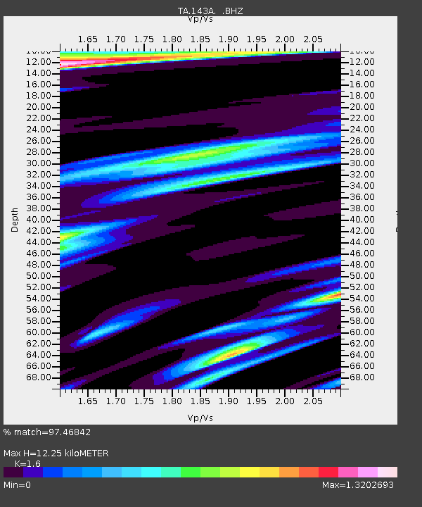
| Estimated Moho Depth: |
12.25 km |
| Estimated Crust Vp/Vs: |
1.60 |
| Assumed Crust Vp: |
6.201 km/s |
| Estimated Crust Vs: |
3.876 km/s |
| Estimated Crust Poisson's Ratio: |
0.18 |
|
| Radial Match: |
97.46842 % |
| Radial Bump: |
400 |
| Transverse Match: |
93.573494 % |
| Transverse Bump: |
400 |
| SOD ConfigId: |
395004 |
| Insert Time: |
2011-12-01 08:49:32.687 +0000 |
| GWidth: |
2.5 |
| Max Bumps: |
400 |
| Tol: |
0.001 |
|
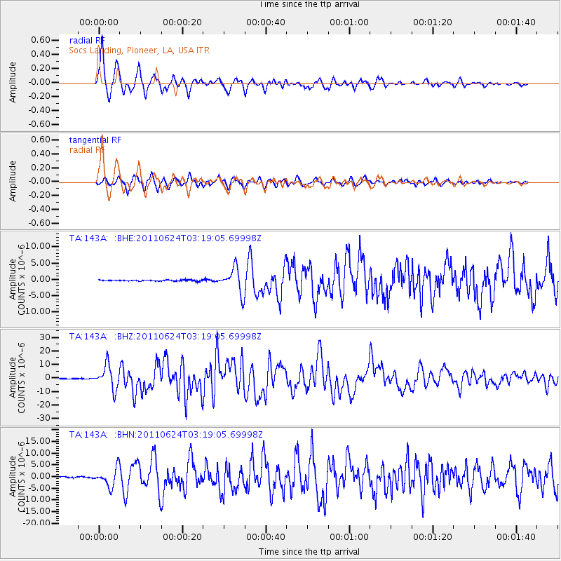
Signal To Noise
| Channel | StoN | STA | LTA |
| TA:143A: :BHZ:20110624T03:19:05.69998Z | 83.11836 | 8.99942E-6 | 1.0827234E-7 |
| TA:143A: :BHN:20110624T03:19:05.69998Z | 23.994242 | 4.058126E-6 | 1.6912915E-7 |
| TA:143A: :BHE:20110624T03:19:05.69998Z | 23.738201 | 4.0169903E-6 | 1.6922048E-7 |
| Arrivals |
| Ps | 1.2 SECOND |
| PpPs | 4.9 SECOND |
| PsPs/PpSs | 6.1 SECOND |


