You are here: Home > Network List > TA - USArray Transportable Network (new EarthScope stations) Stations List
> Station V40A Witts Springs, AR, USA > Earthquake Result Viewer
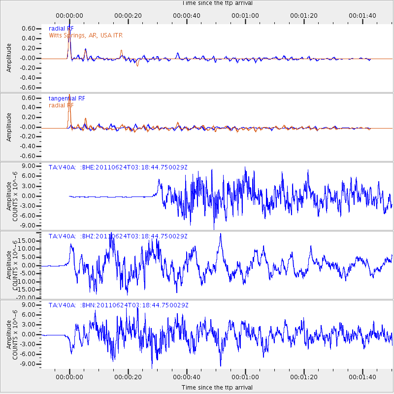
V40A Witts Springs, AR, USA - Earthquake Result Viewer

| Earthquake location: |
Fox Islands, Aleutian Islands |
| Earthquake latitude/longitude: |
52.0/-171.8 |
| Earthquake time(UTC): |
2011/06/24 (175) 03:09:39 GMT |
| Earthquake Depth: |
52 km |
| Earthquake Magnitude: |
6.9 MB, 7.3 MW, 7.3 MW |
| Earthquake Catalog/Contributor: |
WHDF/NEIC |
|
| Network: |
TA USArray Transportable Network (new EarthScope stations) |
| Station: |
V40A Witts Springs, AR, USA |
| Lat/Lon: |
35.80 N/92.82 W |
| Elevation: |
570 m |
|
| Distance: |
56.4 deg |
| Az: |
73.404 deg |
| Baz: |
313.277 deg |
| Ray Param: |
0.06405919 |
| Estimated Moho Depth: |
40.0 km |
| Estimated Crust Vp/Vs: |
1.86 |
| Assumed Crust Vp: |
6.498 km/s |
| Estimated Crust Vs: |
3.493 km/s |
| Estimated Crust Poisson's Ratio: |
0.30 |
|
| Radial Match: |
96.04082 % |
| Radial Bump: |
395 |
| Transverse Match: |
84.43257 % |
| Transverse Bump: |
400 |
| SOD ConfigId: |
395004 |
| Insert Time: |
2011-12-01 08:50:14.405 +0000 |
| GWidth: |
2.5 |
| Max Bumps: |
400 |
| Tol: |
0.001 |
|
Signal To Noise
| Channel | StoN | STA | LTA |
| TA:V40A: :BHZ:20110624T03:18:44.750029Z | 106.79984 | 6.563362E-6 | 6.145479E-8 |
| TA:V40A: :BHN:20110624T03:18:44.750029Z | 41.01795 | 2.6576654E-6 | 6.4792744E-8 |
| TA:V40A: :BHE:20110624T03:18:44.750029Z | 40.268738 | 2.5289248E-6 | 6.280119E-8 |
| Arrivals |
| Ps | 5.6 SECOND |
| PpPs | 17 SECOND |
| PsPs/PpSs | 22 SECOND |


