You are here: Home > Network List > TA - USArray Transportable Network (new EarthScope stations) Stations List
> Station 144A alexander Place, Bentonia, MS, USA > Earthquake Result Viewer
144A alexander Place, Bentonia, MS, USA - Earthquake Result Viewer
| Earthquake location: |
Fox Islands, Aleutian Islands |
| Earthquake latitude/longitude: |
52.0/-171.8 |
| Earthquake time(UTC): |
2011/06/24 (175) 03:09:39 GMT |
| Earthquake Depth: |
52 km |
| Earthquake Magnitude: |
6.9 MB, 7.3 MW, 7.3 MW |
| Earthquake Catalog/Contributor: |
WHDF/NEIC |
|
| Network: |
TA USArray Transportable Network (new EarthScope stations) |
| Station: |
144A alexander Place, Bentonia, MS, USA |
| Lat/Lon: |
32.63 N/90.42 W |
| Elevation: |
78 m |
|
| Distance: |
60.0 deg |
| Az: |
74.441 deg |
| Baz: |
315.168 deg |
| Ray Param: |
0.0616963 |
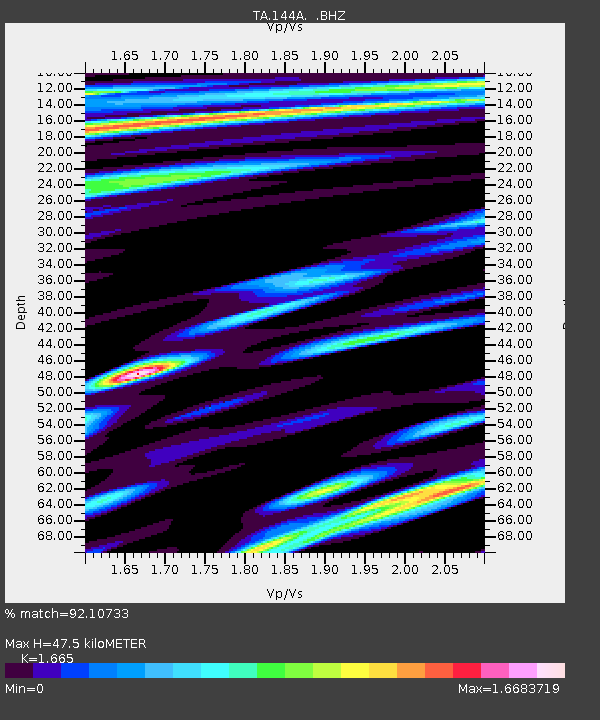
| Estimated Moho Depth: |
47.5 km |
| Estimated Crust Vp/Vs: |
1.66 |
| Assumed Crust Vp: |
6.201 km/s |
| Estimated Crust Vs: |
3.725 km/s |
| Estimated Crust Poisson's Ratio: |
0.22 |
|
| Radial Match: |
92.10733 % |
| Radial Bump: |
400 |
| Transverse Match: |
87.385506 % |
| Transverse Bump: |
400 |
| SOD ConfigId: |
395004 |
| Insert Time: |
2011-12-01 08:51:55.673 +0000 |
| GWidth: |
2.5 |
| Max Bumps: |
400 |
| Tol: |
0.001 |
|

Signal To Noise
| Channel | StoN | STA | LTA |
| TA:144A: :BHZ:20110624T03:19:10.050017Z | 60.379593 | 9.521553E-6 | 1.5769488E-7 |
| TA:144A: :BHN:20110624T03:19:10.050017Z | 7.0470543 | 2.4748888E-6 | 3.511948E-7 |
| TA:144A: :BHE:20110624T03:19:10.050017Z | 4.5535603 | 2.6278208E-6 | 5.7709144E-7 |
| Arrivals |
| Ps | 5.3 SECOND |
| PpPs | 19 SECOND |
| PsPs/PpSs | 25 SECOND |


