You are here: Home > Network List > TA - USArray Transportable Network (new EarthScope stations) Stations List
> Station 145A Houston Renfrow, Canton, MS, USA > Earthquake Result Viewer
145A Houston Renfrow, Canton, MS, USA - Earthquake Result Viewer
| Earthquake location: |
Fox Islands, Aleutian Islands |
| Earthquake latitude/longitude: |
52.0/-171.8 |
| Earthquake time(UTC): |
2011/06/24 (175) 03:09:39 GMT |
| Earthquake Depth: |
52 km |
| Earthquake Magnitude: |
6.9 MB, 7.3 MW, 7.3 MW |
| Earthquake Catalog/Contributor: |
WHDF/NEIC |
|
| Network: |
TA USArray Transportable Network (new EarthScope stations) |
| Station: |
145A Houston Renfrow, Canton, MS, USA |
| Lat/Lon: |
32.60 N/89.93 W |
| Elevation: |
93 m |
|
| Distance: |
60.3 deg |
| Az: |
74.122 deg |
| Baz: |
315.274 deg |
| Ray Param: |
0.0614903 |
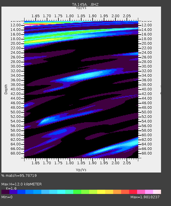
| Estimated Moho Depth: |
12.0 km |
| Estimated Crust Vp/Vs: |
1.60 |
| Assumed Crust Vp: |
6.201 km/s |
| Estimated Crust Vs: |
3.876 km/s |
| Estimated Crust Poisson's Ratio: |
0.18 |
|
| Radial Match: |
95.78719 % |
| Radial Bump: |
400 |
| Transverse Match: |
90.38054 % |
| Transverse Bump: |
400 |
| SOD ConfigId: |
395004 |
| Insert Time: |
2011-12-01 08:52:12.928 +0000 |
| GWidth: |
2.5 |
| Max Bumps: |
400 |
| Tol: |
0.001 |
|
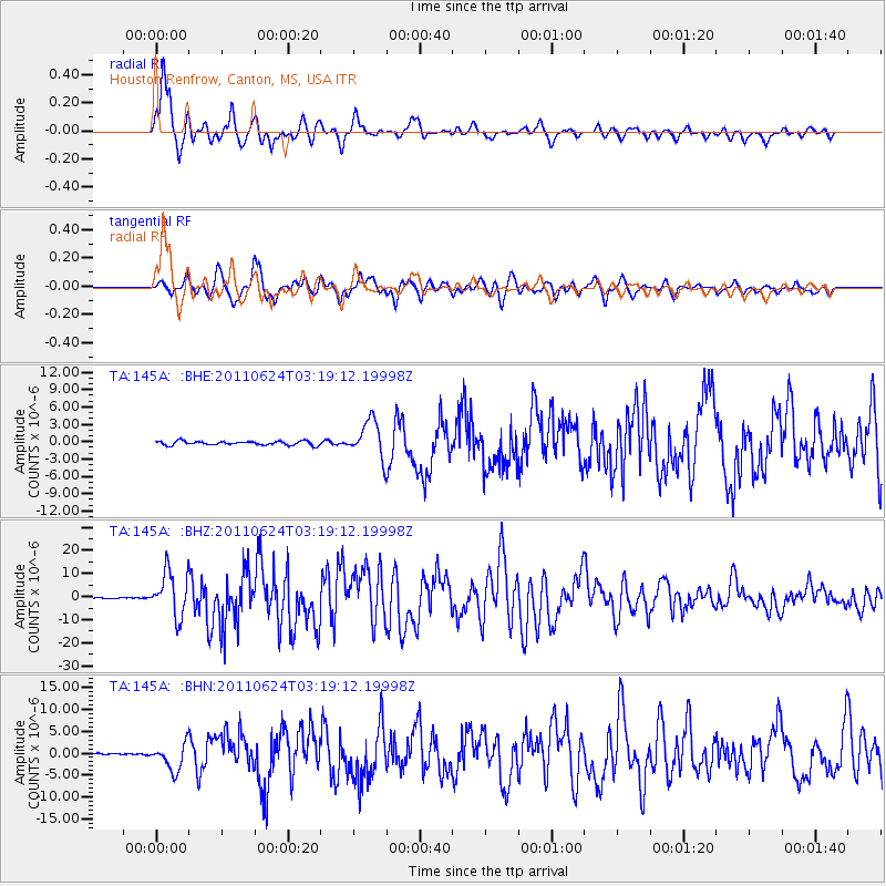
Signal To Noise
| Channel | StoN | STA | LTA |
| TA:145A: :BHZ:20110624T03:19:12.19998Z | 51.921925 | 9.5917985E-6 | 1.8473503E-7 |
| TA:145A: :BHN:20110624T03:19:12.19998Z | 13.704766 | 3.0294918E-6 | 2.2105388E-7 |
| TA:145A: :BHE:20110624T03:19:12.19998Z | 9.396504 | 3.205154E-6 | 3.4110067E-7 |
| Arrivals |
| Ps | 1.2 SECOND |
| PpPs | 4.8 SECOND |
| PsPs/PpSs | 6.0 SECOND |


