You are here: Home > Network List > TA - USArray Transportable Network (new EarthScope stations) Stations List
> Station Z46A Louisville, MS, USA > Earthquake Result Viewer
Z46A Louisville, MS, USA - Earthquake Result Viewer
| Earthquake location: |
Fox Islands, Aleutian Islands |
| Earthquake latitude/longitude: |
52.0/-171.8 |
| Earthquake time(UTC): |
2011/06/24 (175) 03:09:39 GMT |
| Earthquake Depth: |
52 km |
| Earthquake Magnitude: |
6.9 MB, 7.3 MW, 7.3 MW |
| Earthquake Catalog/Contributor: |
WHDF/NEIC |
|
| Network: |
TA USArray Transportable Network (new EarthScope stations) |
| Station: |
Z46A Louisville, MS, USA |
| Lat/Lon: |
33.19 N/88.94 W |
| Elevation: |
125 m |
|
| Distance: |
60.5 deg |
| Az: |
72.967 deg |
| Baz: |
315.237 deg |
| Ray Param: |
0.06138016 |
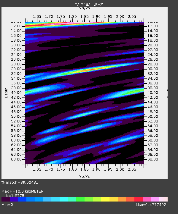
| Estimated Moho Depth: |
10.0 km |
| Estimated Crust Vp/Vs: |
1.88 |
| Assumed Crust Vp: |
6.201 km/s |
| Estimated Crust Vs: |
3.303 km/s |
| Estimated Crust Poisson's Ratio: |
0.30 |
|
| Radial Match: |
89.00481 % |
| Radial Bump: |
400 |
| Transverse Match: |
88.30988 % |
| Transverse Bump: |
400 |
| SOD ConfigId: |
395004 |
| Insert Time: |
2011-12-01 08:54:37.037 +0000 |
| GWidth: |
2.5 |
| Max Bumps: |
400 |
| Tol: |
0.001 |
|
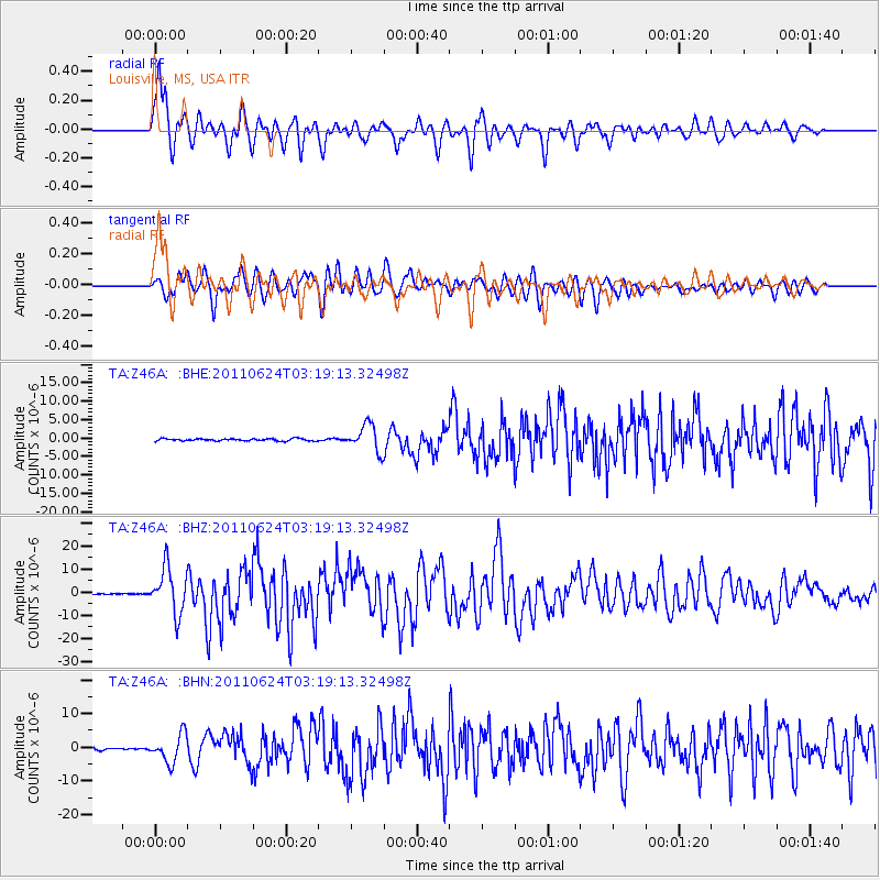
Signal To Noise
| Channel | StoN | STA | LTA |
| TA:Z46A: :BHZ:20110624T03:19:13.32498Z | 61.969944 | 9.8869E-6 | 1.5954348E-7 |
| TA:Z46A: :BHN:20110624T03:19:13.32498Z | 12.002823 | 4.107188E-6 | 3.421852E-7 |
| TA:Z46A: :BHE:20110624T03:19:13.32498Z | 11.9300585 | 3.559596E-6 | 2.9837204E-7 |
| Arrivals |
| Ps | 1.5 SECOND |
| PpPs | 4.5 SECOND |
| PsPs/PpSs | 5.9 SECOND |


