You are here: Home > Network List > TA - USArray Transportable Network (new EarthScope stations) Stations List
> Station 157A Early Branch, SC, USA > Earthquake Result Viewer
157A Early Branch, SC, USA - Earthquake Result Viewer

| Earthquake location: |
Near Coast Of Northern Chile |
| Earthquake latitude/longitude: |
-19.8/-70.9 |
| Earthquake time(UTC): |
2014/03/22 (081) 12:59:59 GMT |
| Earthquake Depth: |
20 km |
| Earthquake Magnitude: |
6.2 MWW, 6.2 MWB, 6.3 MWC, 6.4 MWC |
| Earthquake Catalog/Contributor: |
NEIC PDE/NEIC COMCAT |
|
| Network: |
TA USArray Transportable Network (new EarthScope stations) |
| Station: |
157A Early Branch, SC, USA |
| Lat/Lon: |
32.68 N/81.00 W |
| Elevation: |
21 m |
|
| Distance: |
53.0 deg |
| Az: |
349.308 deg |
| Baz: |
168.043 deg |
| Ray Param: |
0.066344514 |
| Estimated Moho Depth: |
14.25 km |
| Estimated Crust Vp/Vs: |
1.64 |
| Assumed Crust Vp: |
6.565 km/s |
| Estimated Crust Vs: |
4.009 km/s |
| Estimated Crust Poisson's Ratio: |
0.20 |
|
| Radial Match: |
90.142746 % |
| Radial Bump: |
400 |
| Transverse Match: |
75.46346 % |
| Transverse Bump: |
400 |
| SOD ConfigId: |
3390531 |
| Insert Time: |
2019-04-10 19:50:25.574 +0000 |
| GWidth: |
2.5 |
| Max Bumps: |
400 |
| Tol: |
0.001 |
|
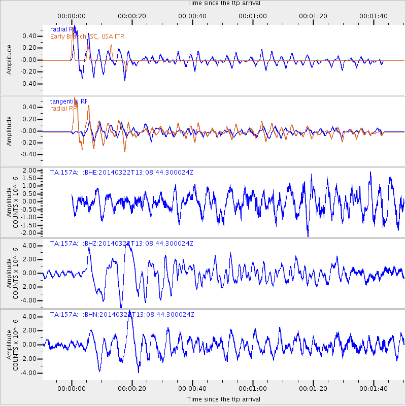
Signal To Noise
| Channel | StoN | STA | LTA |
| TA:157A: :BHZ:20140322T13:08:44.300024Z | 1.2441336 | 3.3071862E-7 | 2.6582245E-7 |
| TA:157A: :BHN:20140322T13:08:44.300024Z | 0.9926667 | 3.896151E-7 | 3.9249335E-7 |
| TA:157A: :BHE:20140322T13:08:44.300024Z | 1.0115671 | 4.0549824E-7 | 4.0086144E-7 |
| Arrivals |
| Ps | 1.5 SECOND |
| PpPs | 5.4 SECOND |
| PsPs/PpSs | 6.9 SECOND |


