You are here: Home > Network List > TA - USArray Transportable Network (new EarthScope stations) Stations List
> Station L63A North Scituate, RI, USA > Earthquake Result Viewer
L63A North Scituate, RI, USA - Earthquake Result Viewer
| Earthquake location: |
Near Coast Of Northern Chile |
| Earthquake latitude/longitude: |
-19.8/-70.9 |
| Earthquake time(UTC): |
2014/03/22 (081) 12:59:59 GMT |
| Earthquake Depth: |
20 km |
| Earthquake Magnitude: |
6.2 MWW, 6.2 MWB, 6.3 MWC, 6.4 MWC |
| Earthquake Catalog/Contributor: |
NEIC PDE/NEIC COMCAT |
|
| Network: |
TA USArray Transportable Network (new EarthScope stations) |
| Station: |
L63A North Scituate, RI, USA |
| Lat/Lon: |
41.86 N/71.61 W |
| Elevation: |
109 m |
|
| Distance: |
61.3 deg |
| Az: |
359.374 deg |
| Baz: |
179.21 deg |
| Ray Param: |
0.060929295 |
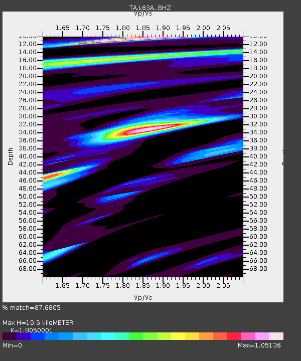
| Estimated Moho Depth: |
10.5 km |
| Estimated Crust Vp/Vs: |
1.81 |
| Assumed Crust Vp: |
6.472 km/s |
| Estimated Crust Vs: |
3.586 km/s |
| Estimated Crust Poisson's Ratio: |
0.28 |
|
| Radial Match: |
87.6805 % |
| Radial Bump: |
346 |
| Transverse Match: |
71.859436 % |
| Transverse Bump: |
400 |
| SOD ConfigId: |
3390531 |
| Insert Time: |
2019-04-10 19:51:07.649 +0000 |
| GWidth: |
2.5 |
| Max Bumps: |
400 |
| Tol: |
0.001 |
|

Signal To Noise
| Channel | StoN | STA | LTA |
| TA:L63A: :BHZ:20140322T13:09:42.800024Z | 1.7712673 | 6.5731376E-7 | 3.71098E-7 |
| TA:L63A: :BHN:20140322T13:09:42.800024Z | 1.0540568 | 2.4787664E-7 | 2.3516442E-7 |
| TA:L63A: :BHE:20140322T13:09:42.800024Z | 1.8876351 | 4.327292E-7 | 2.292441E-7 |
| Arrivals |
| Ps | 1.4 SECOND |
| PpPs | 4.3 SECOND |
| PsPs/PpSs | 5.7 SECOND |


