You are here: Home > Network List > TA - USArray Transportable Network (new EarthScope stations) Stations List
> Station M59A Waymart, PA, USA > Earthquake Result Viewer
M59A Waymart, PA, USA - Earthquake Result Viewer
| Earthquake location: |
Near Coast Of Northern Chile |
| Earthquake latitude/longitude: |
-19.8/-70.9 |
| Earthquake time(UTC): |
2014/03/22 (081) 12:59:59 GMT |
| Earthquake Depth: |
20 km |
| Earthquake Magnitude: |
6.2 MWW, 6.2 MWB, 6.3 MWC, 6.4 MWC |
| Earthquake Catalog/Contributor: |
NEIC PDE/NEIC COMCAT |
|
| Network: |
TA USArray Transportable Network (new EarthScope stations) |
| Station: |
M59A Waymart, PA, USA |
| Lat/Lon: |
41.54 N/75.43 W |
| Elevation: |
471 m |
|
| Distance: |
61.1 deg |
| Az: |
356.094 deg |
| Baz: |
175.097 deg |
| Ray Param: |
0.06104756 |
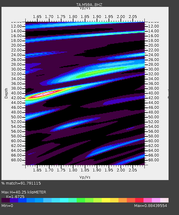
| Estimated Moho Depth: |
40.25 km |
| Estimated Crust Vp/Vs: |
1.67 |
| Assumed Crust Vp: |
6.283 km/s |
| Estimated Crust Vs: |
3.757 km/s |
| Estimated Crust Poisson's Ratio: |
0.22 |
|
| Radial Match: |
91.791115 % |
| Radial Bump: |
329 |
| Transverse Match: |
78.02064 % |
| Transverse Bump: |
396 |
| SOD ConfigId: |
3390531 |
| Insert Time: |
2019-04-10 19:51:12.193 +0000 |
| GWidth: |
2.5 |
| Max Bumps: |
400 |
| Tol: |
0.001 |
|
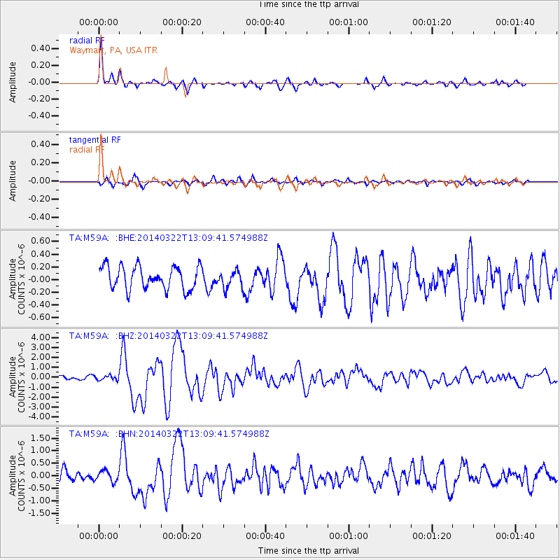
Signal To Noise
| Channel | StoN | STA | LTA |
| TA:M59A: :BHZ:20140322T13:09:41.574988Z | 1.0167185 | 2.4342665E-7 | 2.3942385E-7 |
| TA:M59A: :BHN:20140322T13:09:41.574988Z | 1.2821742 | 2.2397178E-7 | 1.7468123E-7 |
| TA:M59A: :BHE:20140322T13:09:41.574988Z | 0.6897961 | 1.2235725E-7 | 1.7738175E-7 |
| Arrivals |
| Ps | 4.5 SECOND |
| PpPs | 16 SECOND |
| PsPs/PpSs | 21 SECOND |


