You are here: Home > Network List > TA - USArray Transportable Network (new EarthScope stations) Stations List
> Station P54A Burton, WV, USA > Earthquake Result Viewer
P54A Burton, WV, USA - Earthquake Result Viewer
| Earthquake location: |
Near Coast Of Northern Chile |
| Earthquake latitude/longitude: |
-19.8/-70.9 |
| Earthquake time(UTC): |
2014/03/22 (081) 12:59:59 GMT |
| Earthquake Depth: |
20 km |
| Earthquake Magnitude: |
6.2 MWW, 6.2 MWB, 6.3 MWC, 6.4 MWC |
| Earthquake Catalog/Contributor: |
NEIC PDE/NEIC COMCAT |
|
| Network: |
TA USArray Transportable Network (new EarthScope stations) |
| Station: |
P54A Burton, WV, USA |
| Lat/Lon: |
39.61 N/80.48 W |
| Elevation: |
473 m |
|
| Distance: |
59.7 deg |
| Az: |
351.417 deg |
| Baz: |
169.517 deg |
| Ray Param: |
0.061967287 |
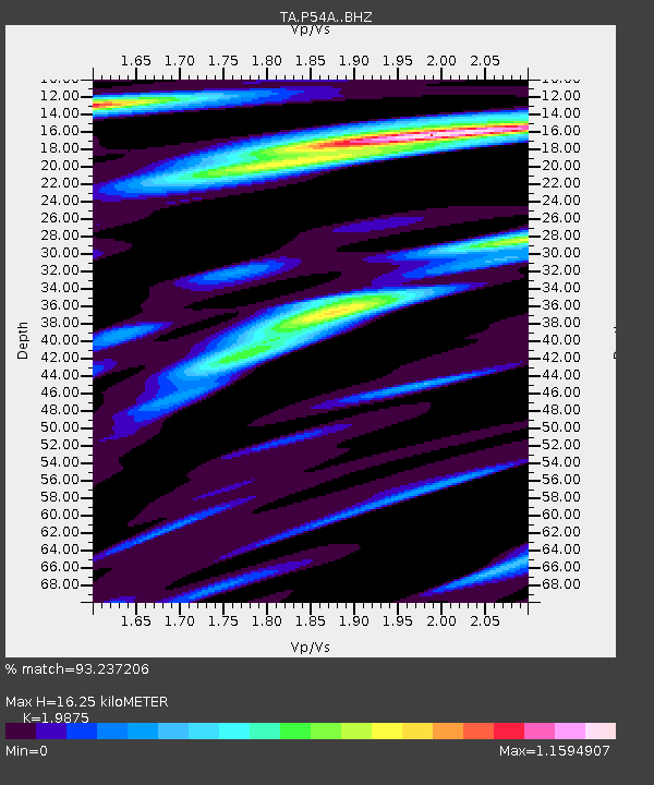
| Estimated Moho Depth: |
16.25 km |
| Estimated Crust Vp/Vs: |
1.99 |
| Assumed Crust Vp: |
6.207 km/s |
| Estimated Crust Vs: |
3.123 km/s |
| Estimated Crust Poisson's Ratio: |
0.33 |
|
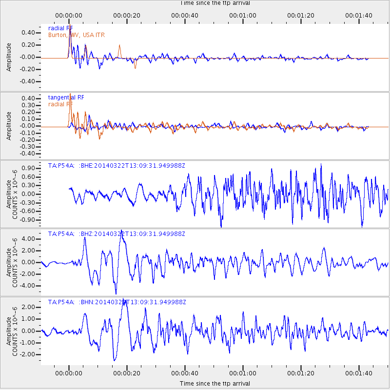
| Radial Match: |
93.237206 % |
| Radial Bump: |
400 |
| Transverse Match: |
82.17023 % |
| Transverse Bump: |
400 |
| SOD ConfigId: |
3390531 |
| Insert Time: |
2019-04-10 19:51:27.189 +0000 |
| GWidth: |
2.5 |
| Max Bumps: |
400 |
| Tol: |
0.001 |
|
Signal To Noise
| Channel | StoN | STA | LTA |
| TA:P54A: :BHZ:20140322T13:09:31.949988Z | 1.4072908 | 4.0938622E-7 | 2.9090378E-7 |
| TA:P54A: :BHN:20140322T13:09:31.949988Z | 1.3276471 | 2.2440608E-7 | 1.690254E-7 |
| TA:P54A: :BHE:20140322T13:09:31.949988Z | 0.66690093 | 1.0486507E-7 | 1.5724237E-7 |
| Arrivals |
| Ps | 2.7 SECOND |
| PpPs | 7.5 SECOND |
| PsPs/PpSs | 10 SECOND |


