You are here: Home > Network List > TA - USArray Transportable Network (new EarthScope stations) Stations List
> Station Q59A Harwood, MD, USA > Earthquake Result Viewer
Q59A Harwood, MD, USA - Earthquake Result Viewer

| Earthquake location: |
Near Coast Of Northern Chile |
| Earthquake latitude/longitude: |
-19.8/-70.9 |
| Earthquake time(UTC): |
2014/03/22 (081) 12:59:59 GMT |
| Earthquake Depth: |
20 km |
| Earthquake Magnitude: |
6.2 MWW, 6.2 MWB, 6.3 MWC, 6.4 MWC |
| Earthquake Catalog/Contributor: |
NEIC PDE/NEIC COMCAT |
|
| Network: |
TA USArray Transportable Network (new EarthScope stations) |
| Station: |
Q59A Harwood, MD, USA |
| Lat/Lon: |
38.86 N/76.65 W |
| Elevation: |
34 m |
|
| Distance: |
58.6 deg |
| Az: |
354.712 deg |
| Baz: |
173.617 deg |
| Ray Param: |
0.0627365 |
| Estimated Moho Depth: |
10.75 km |
| Estimated Crust Vp/Vs: |
1.60 |
| Assumed Crust Vp: |
6.419 km/s |
| Estimated Crust Vs: |
4.012 km/s |
| Estimated Crust Poisson's Ratio: |
0.18 |
|
| Radial Match: |
87.68148 % |
| Radial Bump: |
400 |
| Transverse Match: |
68.8548 % |
| Transverse Bump: |
400 |
| SOD ConfigId: |
3390531 |
| Insert Time: |
2019-04-10 19:51:31.672 +0000 |
| GWidth: |
2.5 |
| Max Bumps: |
400 |
| Tol: |
0.001 |
|
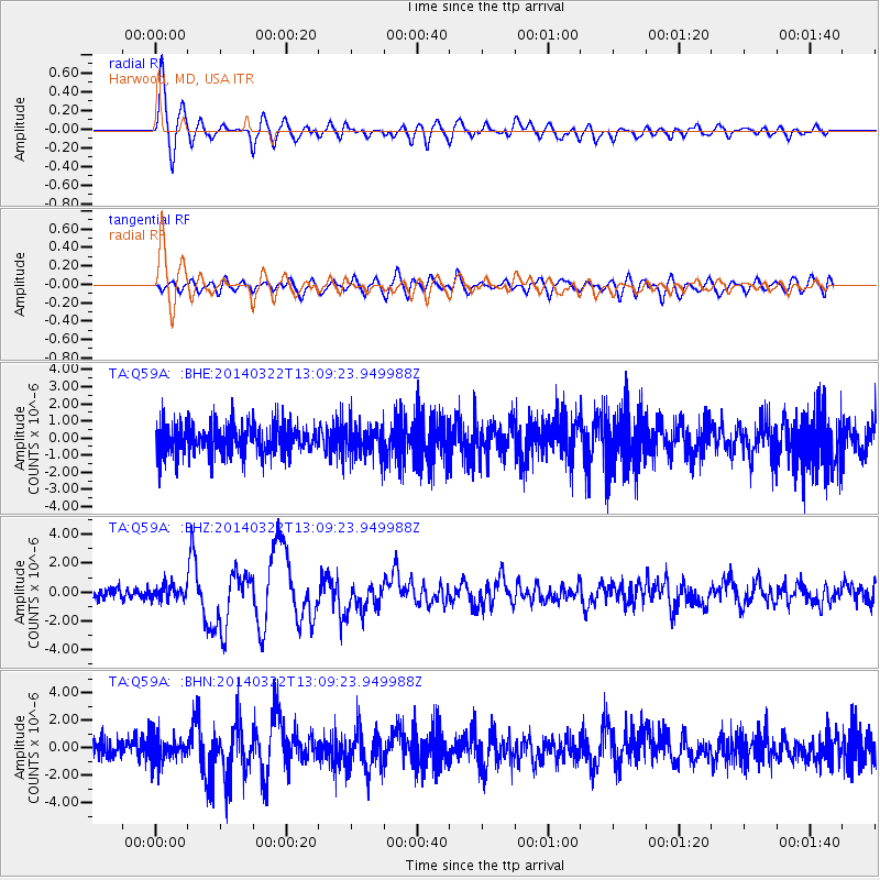
Signal To Noise
| Channel | StoN | STA | LTA |
| TA:Q59A: :BHZ:20140322T13:09:23.949988Z | 1.3830612 | 4.7461756E-7 | 3.4316454E-7 |
| TA:Q59A: :BHN:20140322T13:09:23.949988Z | 1.3215241 | 9.3938064E-7 | 7.108313E-7 |
| TA:Q59A: :BHE:20140322T13:09:23.949988Z | 0.9964873 | 9.192188E-7 | 9.224591E-7 |
| Arrivals |
| Ps | 1.1 SECOND |
| PpPs | 4.1 SECOND |
| PsPs/PpSs | 5.2 SECOND |


