You are here: Home > Network List > TA - USArray Transportable Network (new EarthScope stations) Stations List
> Station S55A Lewisburg, WV, USA > Earthquake Result Viewer
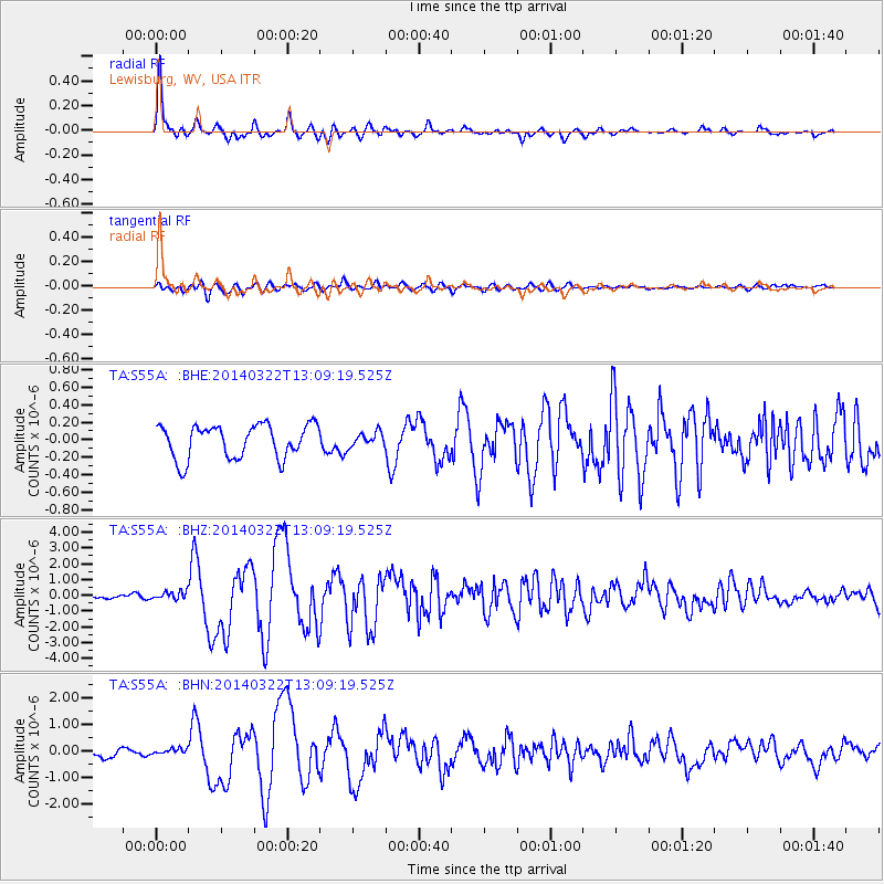
S55A Lewisburg, WV, USA - Earthquake Result Viewer

| Earthquake location: |
Near Coast Of Northern Chile |
| Earthquake latitude/longitude: |
-19.8/-70.9 |
| Earthquake time(UTC): |
2014/03/22 (081) 12:59:59 GMT |
| Earthquake Depth: |
20 km |
| Earthquake Magnitude: |
6.2 MWW, 6.2 MWB, 6.3 MWC, 6.4 MWC |
| Earthquake Catalog/Contributor: |
NEIC PDE/NEIC COMCAT |
|
| Network: |
TA USArray Transportable Network (new EarthScope stations) |
| Station: |
S55A Lewisburg, WV, USA |
| Lat/Lon: |
37.77 N/80.50 W |
| Elevation: |
647 m |
|
| Distance: |
57.9 deg |
| Az: |
351.004 deg |
| Baz: |
169.289 deg |
| Ray Param: |
0.06314591 |
| Estimated Moho Depth: |
47.0 km |
| Estimated Crust Vp/Vs: |
1.72 |
| Assumed Crust Vp: |
6.159 km/s |
| Estimated Crust Vs: |
3.575 km/s |
| Estimated Crust Poisson's Ratio: |
0.25 |
|
| Radial Match: |
94.88752 % |
| Radial Bump: |
330 |
| Transverse Match: |
73.17421 % |
| Transverse Bump: |
400 |
| SOD ConfigId: |
3390531 |
| Insert Time: |
2019-04-10 19:51:37.441 +0000 |
| GWidth: |
2.5 |
| Max Bumps: |
400 |
| Tol: |
0.001 |
|
Signal To Noise
| Channel | StoN | STA | LTA |
| TA:S55A: :BHZ:20140322T13:09:19.525Z | 1.5007082 | 2.6244322E-7 | 1.7487959E-7 |
| TA:S55A: :BHN:20140322T13:09:19.525Z | 0.7733402 | 1.0165964E-7 | 1.3145525E-7 |
| TA:S55A: :BHE:20140322T13:09:19.525Z | 0.501978 | 9.5867634E-8 | 1.9097976E-7 |
| Arrivals |
| Ps | 5.8 SECOND |
| PpPs | 20 SECOND |
| PsPs/PpSs | 26 SECOND |


