You are here: Home > Network List > II - Global Seismograph Network (GSN - IRIS/IDA) Stations List
> Station PFO Pinon Flat, California, USA > Earthquake Result Viewer
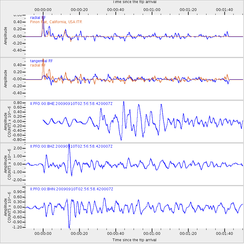
PFO Pinon Flat, California, USA - Earthquake Result Viewer
*The percent match for this event was below the threshold and hence no stack was calculated.
| Earthquake location: |
Kuril Islands |
| Earthquake latitude/longitude: |
48.3/154.2 |
| Earthquake time(UTC): |
2009/09/10 (253) 02:46:50 GMT |
| Earthquake Depth: |
36 km |
| Earthquake Magnitude: |
6.0 MB, 5.5 MS, 6.0 MW, 5.8 MW |
| Earthquake Catalog/Contributor: |
WHDF/NEIC |
|
| Network: |
II Global Seismograph Network (GSN - IRIS/IDA) |
| Station: |
PFO Pinon Flat, California, USA |
| Lat/Lon: |
33.61 N/116.46 W |
| Elevation: |
1280 m |
|
| Distance: |
65.4 deg |
| Az: |
66.621 deg |
| Baz: |
312.762 deg |
| Ray Param: |
$rayparam |
*The percent match for this event was below the threshold and hence was not used in the summary stack. |
|
| Radial Match: |
76.403694 % |
| Radial Bump: |
391 |
| Transverse Match: |
56.00324 % |
| Transverse Bump: |
396 |
| SOD ConfigId: |
1 |
| Insert Time: |
2010-02-19 00:11:48.077 +0000 |
| GWidth: |
2.5 |
| Max Bumps: |
400 |
| Tol: |
0.001 |
|
Signal To Noise
| Channel | StoN | STA | LTA |
| II:PFO:00:BHZ:20090910T02:56:58.420007Z | 3.4946716 | 5.2563297E-7 | 1.5040983E-7 |
| II:PFO:00:BHN:20090910T02:56:58.420007Z | 3.2371266 | 2.2649802E-7 | 6.996885E-8 |
| II:PFO:00:BHE:20090910T02:56:58.420007Z | 3.189986 | 2.643645E-7 | 8.287325E-8 |
| Arrivals |
| Ps | |
| PpPs | |
| PsPs/PpSs | |


