You are here: Home > Network List > BK - Berkeley Digital Seismograph Network Stations List
> Station HUMO Hull Mountain, OR > Earthquake Result Viewer
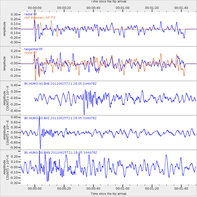
HUMO Hull Mountain, OR - Earthquake Result Viewer
*The percent match for this event was below the threshold and hence no stack was calculated.
| Earthquake location: |
South Of Fiji Islands |
| Earthquake latitude/longitude: |
-24.5/179.4 |
| Earthquake time(UTC): |
2011/06/25 (176) 21:16:55 GMT |
| Earthquake Depth: |
528 km |
| Earthquake Magnitude: |
5.5 MB, 5.6 MW, 5.6 MW |
| Earthquake Catalog/Contributor: |
WHDF/NEIC |
|
| Network: |
BK Berkeley Digital Seismograph Network |
| Station: |
HUMO Hull Mountain, OR |
| Lat/Lon: |
42.61 N/122.96 W |
| Elevation: |
555 m |
|
| Distance: |
85.3 deg |
| Az: |
38.75 deg |
| Baz: |
230.561 deg |
| Ray Param: |
$rayparam |
*The percent match for this event was below the threshold and hence was not used in the summary stack. |
|
| Radial Match: |
61.075596 % |
| Radial Bump: |
400 |
| Transverse Match: |
46.062946 % |
| Transverse Bump: |
400 |
| SOD ConfigId: |
395004 |
| Insert Time: |
2011-12-08 04:29:33.120 +0000 |
| GWidth: |
2.5 |
| Max Bumps: |
400 |
| Tol: |
0.001 |
|
Signal To Noise
| Channel | StoN | STA | LTA |
| BK:HUMO:00:BHZ:20110625T21:28:05.394978Z | 4.7511854 | 3.689039E-7 | 7.76446E-8 |
| BK:HUMO:00:BHN:20110625T21:28:05.394978Z | 1.6592635 | 8.9035154E-8 | 5.3659445E-8 |
| BK:HUMO:00:BHE:20110625T21:28:05.394978Z | 1.6131524 | 1.5957131E-7 | 9.891893E-8 |
| Arrivals |
| Ps | |
| PpPs | |
| PsPs/PpSs | |


