You are here: Home > Network List > G - GEOSCOPE Stations List
> Station ATD Arta Cave, Djibouti > Earthquake Result Viewer
ATD Arta Cave, Djibouti - Earthquake Result Viewer
| Earthquake location: |
Samar, Philippines |
| Earthquake latitude/longitude: |
11.6/125.9 |
| Earthquake time(UTC): |
1995/05/08 (128) 18:08:09 GMT |
| Earthquake Depth: |
33 km |
| Earthquake Magnitude: |
5.6 MB, 6.2 MS, 6.3 UNKNOWN, 6.3 MW |
| Earthquake Catalog/Contributor: |
WHDF/NEIC |
|
| Network: |
G GEOSCOPE |
| Station: |
ATD Arta Cave, Djibouti |
| Lat/Lon: |
11.53 N/42.85 E |
| Elevation: |
610 m |
|
| Distance: |
81.0 deg |
| Az: |
279.969 deg |
| Baz: |
79.989 deg |
| Ray Param: |
0.047820307 |
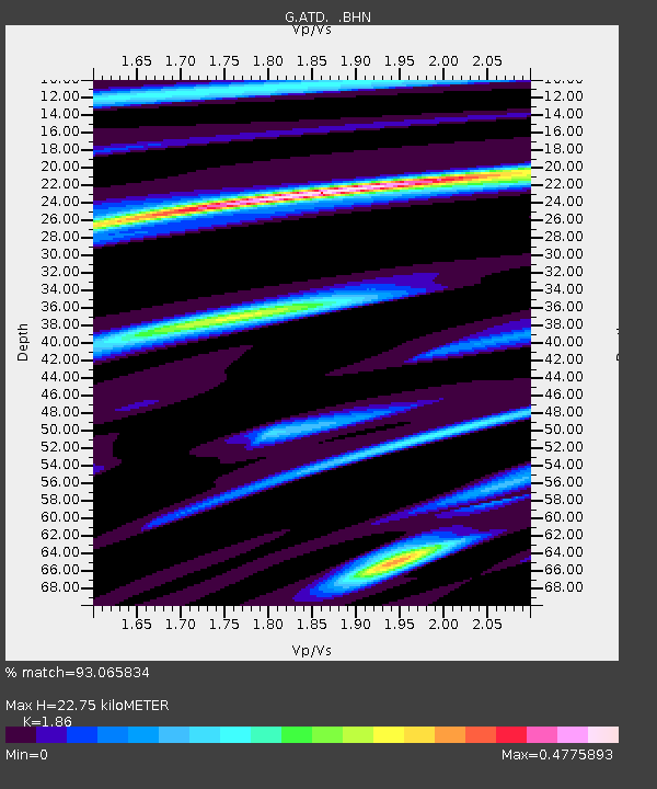
| Estimated Moho Depth: |
22.75 km |
| Estimated Crust Vp/Vs: |
1.86 |
| Assumed Crust Vp: |
6.375 km/s |
| Estimated Crust Vs: |
3.427 km/s |
| Estimated Crust Poisson's Ratio: |
0.30 |
|
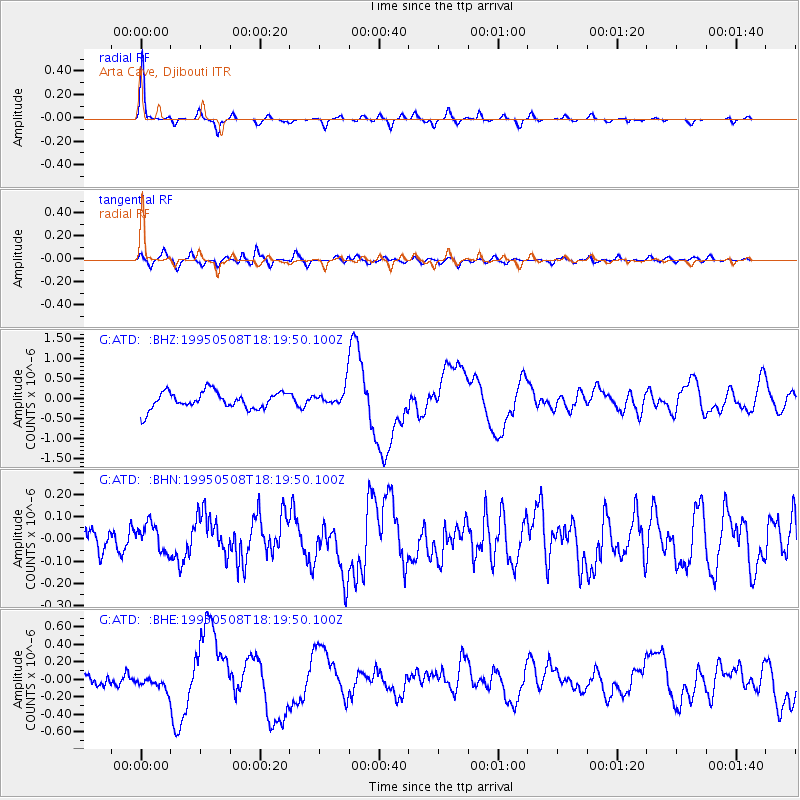
| Radial Match: |
93.065834 % |
| Radial Bump: |
240 |
| Transverse Match: |
80.30486 % |
| Transverse Bump: |
400 |
| SOD ConfigId: |
6273 |
| Insert Time: |
2010-02-26 21:27:45.529 +0000 |
| GWidth: |
2.5 |
| Max Bumps: |
400 |
| Tol: |
0.001 |
|
Signal To Noise
| Channel | StoN | STA | LTA |
| G:ATD: :BHN:19950508T18:19:50.100Z | 1.302348 | 6.184489E-8 | 4.748722E-8 |
| G:ATD: :BHE:19950508T18:19:50.100Z | 0.66481316 | 8.668597E-8 | 1.3039148E-7 |
| G:ATD: :BHZ:19950508T18:19:50.100Z | 1.0890081 | 2.3482932E-7 | 2.1563598E-7 |
| Arrivals |
| Ps | 3.1 SECOND |
| PpPs | 9.9 SECOND |
| PsPs/PpSs | 13 SECOND |


