You are here: Home > Network List > IW - Intermountain West Stations List
> Station MOOW Moose Ponds, Wyoming, USA > Earthquake Result Viewer
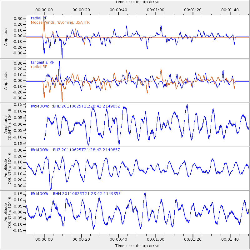
MOOW Moose Ponds, Wyoming, USA - Earthquake Result Viewer
*The percent match for this event was below the threshold and hence no stack was calculated.
| Earthquake location: |
South Of Fiji Islands |
| Earthquake latitude/longitude: |
-24.5/179.4 |
| Earthquake time(UTC): |
2011/06/25 (176) 21:16:55 GMT |
| Earthquake Depth: |
528 km |
| Earthquake Magnitude: |
5.5 MB, 5.6 MW, 5.6 MW |
| Earthquake Catalog/Contributor: |
WHDF/NEIC |
|
| Network: |
IW Intermountain West |
| Station: |
MOOW Moose Ponds, Wyoming, USA |
| Lat/Lon: |
43.75 N/110.74 W |
| Elevation: |
2128 m |
|
| Distance: |
93.3 deg |
| Az: |
42.97 deg |
| Baz: |
238.955 deg |
| Ray Param: |
$rayparam |
*The percent match for this event was below the threshold and hence was not used in the summary stack. |
|
| Radial Match: |
50.22843 % |
| Radial Bump: |
400 |
| Transverse Match: |
67.53664 % |
| Transverse Bump: |
400 |
| SOD ConfigId: |
395004 |
| Insert Time: |
2011-12-08 04:33:35.982 +0000 |
| GWidth: |
2.5 |
| Max Bumps: |
400 |
| Tol: |
0.001 |
|
Signal To Noise
| Channel | StoN | STA | LTA |
| IW:MOOW: :BHZ:20110625T21:28:42.214985Z | 2.3166165 | 1.7943469E-7 | 7.7455496E-8 |
| IW:MOOW: :BHN:20110625T21:28:42.214985Z | 1.1399058 | 4.4871765E-8 | 3.936445E-8 |
| IW:MOOW: :BHE:20110625T21:28:42.214985Z | 1.3910259 | 7.5847026E-8 | 5.4525962E-8 |
| Arrivals |
| Ps | |
| PpPs | |
| PsPs/PpSs | |


