You are here: Home > Network List > TA - USArray Transportable Network (new EarthScope stations) Stations List
> Station Y58A Scranton, SC, USA > Earthquake Result Viewer
Y58A Scranton, SC, USA - Earthquake Result Viewer

| Earthquake location: |
Near Coast Of Northern Chile |
| Earthquake latitude/longitude: |
-19.8/-70.9 |
| Earthquake time(UTC): |
2014/03/22 (081) 12:59:59 GMT |
| Earthquake Depth: |
20 km |
| Earthquake Magnitude: |
6.2 MWW, 6.2 MWB, 6.3 MWC, 6.4 MWC |
| Earthquake Catalog/Contributor: |
NEIC PDE/NEIC COMCAT |
|
| Network: |
TA USArray Transportable Network (new EarthScope stations) |
| Station: |
Y58A Scranton, SC, USA |
| Lat/Lon: |
33.91 N/79.67 W |
| Elevation: |
19 m |
|
| Distance: |
54.0 deg |
| Az: |
350.962 deg |
| Baz: |
169.753 deg |
| Ray Param: |
0.06568406 |
| Estimated Moho Depth: |
18.75 km |
| Estimated Crust Vp/Vs: |
1.91 |
| Assumed Crust Vp: |
6.24 km/s |
| Estimated Crust Vs: |
3.271 km/s |
| Estimated Crust Poisson's Ratio: |
0.31 |
|
| Radial Match: |
96.15975 % |
| Radial Bump: |
381 |
| Transverse Match: |
86.228584 % |
| Transverse Bump: |
400 |
| SOD ConfigId: |
3390531 |
| Insert Time: |
2019-04-10 19:51:57.518 +0000 |
| GWidth: |
2.5 |
| Max Bumps: |
400 |
| Tol: |
0.001 |
|
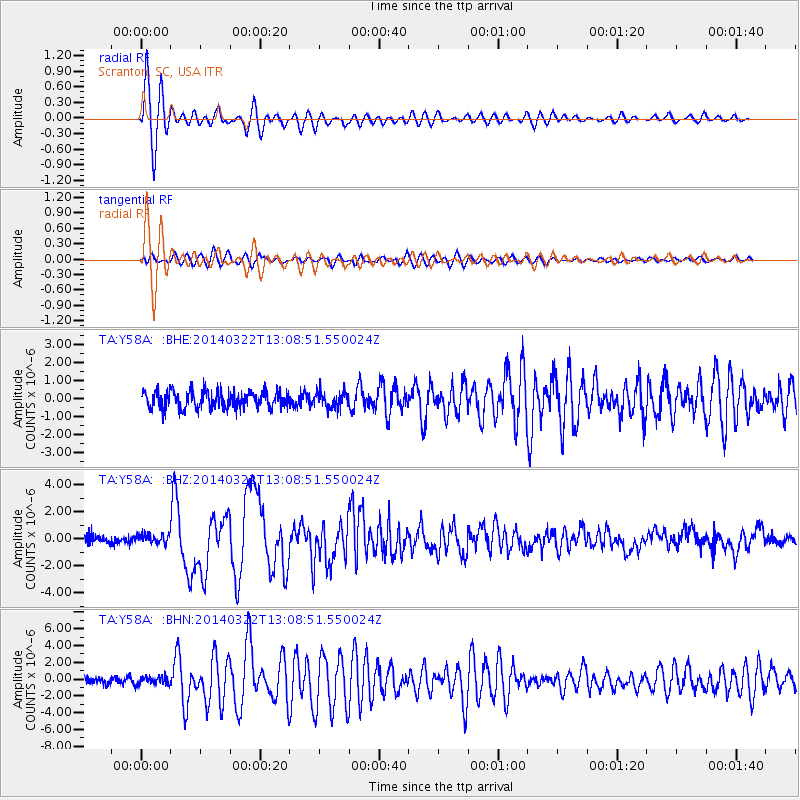
Signal To Noise
| Channel | StoN | STA | LTA |
| TA:Y58A: :BHZ:20140322T13:08:51.550024Z | 1.0841252 | 3.501848E-7 | 3.230114E-7 |
| TA:Y58A: :BHN:20140322T13:08:51.550024Z | 1.234427 | 4.6826423E-7 | 3.7933734E-7 |
| TA:Y58A: :BHE:20140322T13:08:51.550024Z | 0.9069225 | 4.2584892E-7 | 4.695538E-7 |
| Arrivals |
| Ps | 2.9 SECOND |
| PpPs | 8.3 SECOND |
| PsPs/PpSs | 11 SECOND |


