You are here: Home > Network List > TA - USArray Transportable Network (new EarthScope stations) Stations List
> Station Y60A Bolivia, NC, USA > Earthquake Result Viewer
Y60A Bolivia, NC, USA - Earthquake Result Viewer
| Earthquake location: |
Near Coast Of Northern Chile |
| Earthquake latitude/longitude: |
-19.8/-70.9 |
| Earthquake time(UTC): |
2014/03/22 (081) 12:59:59 GMT |
| Earthquake Depth: |
20 km |
| Earthquake Magnitude: |
6.2 MWW, 6.2 MWB, 6.3 MWC, 6.4 MWC |
| Earthquake Catalog/Contributor: |
NEIC PDE/NEIC COMCAT |
|
| Network: |
TA USArray Transportable Network (new EarthScope stations) |
| Station: |
Y60A Bolivia, NC, USA |
| Lat/Lon: |
34.00 N/78.22 W |
| Elevation: |
7.0 m |
|
| Distance: |
53.9 deg |
| Az: |
352.452 deg |
| Baz: |
171.436 deg |
| Ray Param: |
0.065749876 |
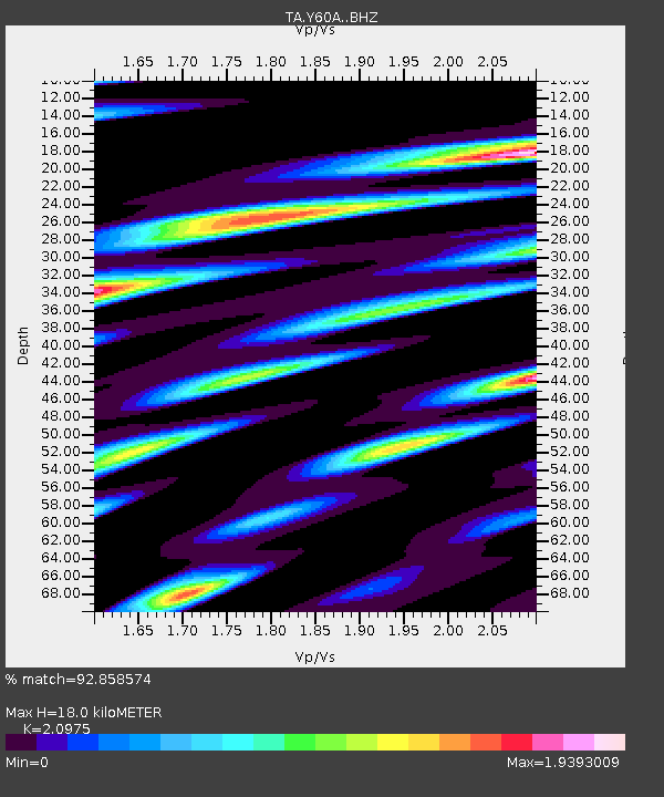
| Estimated Moho Depth: |
18.0 km |
| Estimated Crust Vp/Vs: |
2.10 |
| Assumed Crust Vp: |
6.565 km/s |
| Estimated Crust Vs: |
3.13 km/s |
| Estimated Crust Poisson's Ratio: |
0.35 |
|
| Radial Match: |
92.858574 % |
| Radial Bump: |
400 |
| Transverse Match: |
78.397224 % |
| Transverse Bump: |
400 |
| SOD ConfigId: |
3390531 |
| Insert Time: |
2019-04-10 19:51:58.092 +0000 |
| GWidth: |
2.5 |
| Max Bumps: |
400 |
| Tol: |
0.001 |
|
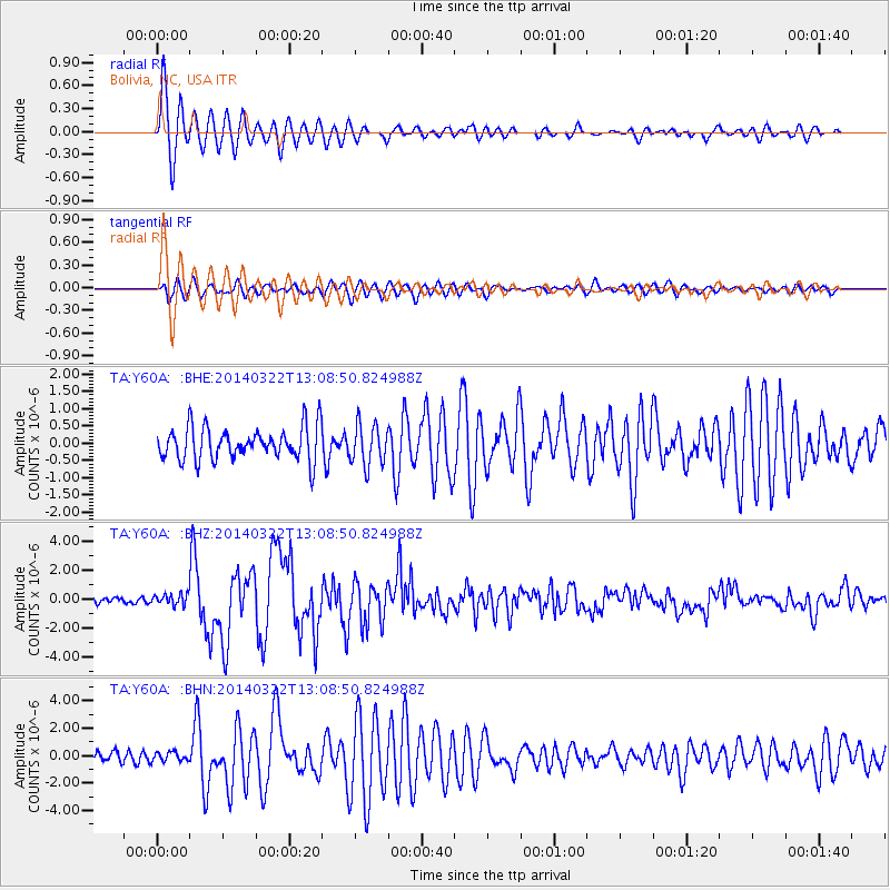
Signal To Noise
| Channel | StoN | STA | LTA |
| TA:Y60A: :BHZ:20140322T13:08:50.824988Z | 1.9067035 | 4.1124406E-7 | 2.1568327E-7 |
| TA:Y60A: :BHN:20140322T13:08:50.824988Z | 0.59051 | 3.3186663E-7 | 5.62E-7 |
| TA:Y60A: :BHE:20140322T13:08:50.824988Z | 1.3332561 | 5.944402E-7 | 4.4585602E-7 |
| Arrivals |
| Ps | 3.2 SECOND |
| PpPs | 8.1 SECOND |
| PsPs/PpSs | 11 SECOND |


