You are here: Home > Network List > TA - USArray Transportable Network (new EarthScope stations) Stations List
> Station L04D Klamath Falls, OR, USA > Earthquake Result Viewer
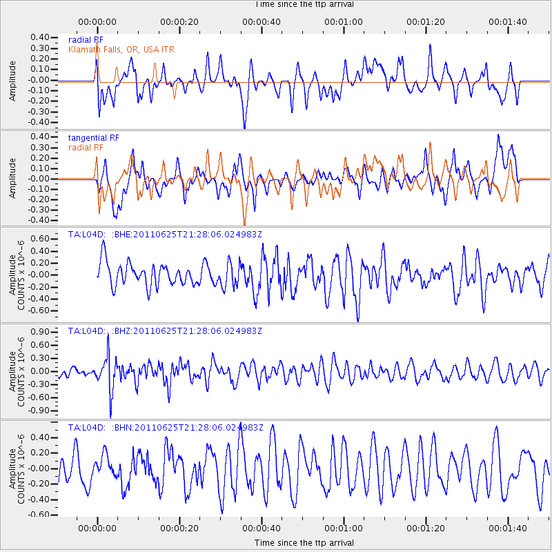
L04D Klamath Falls, OR, USA - Earthquake Result Viewer
*The percent match for this event was below the threshold and hence no stack was calculated.
| Earthquake location: |
South Of Fiji Islands |
| Earthquake latitude/longitude: |
-24.5/179.4 |
| Earthquake time(UTC): |
2011/06/25 (176) 21:16:55 GMT |
| Earthquake Depth: |
528 km |
| Earthquake Magnitude: |
5.5 MB, 5.6 MW, 5.6 MW |
| Earthquake Catalog/Contributor: |
WHDF/NEIC |
|
| Network: |
TA USArray Transportable Network (new EarthScope stations) |
| Station: |
L04D Klamath Falls, OR, USA |
| Lat/Lon: |
42.22 N/122.30 W |
| Elevation: |
1437 m |
|
| Distance: |
85.5 deg |
| Az: |
39.359 deg |
| Baz: |
231.048 deg |
| Ray Param: |
$rayparam |
*The percent match for this event was below the threshold and hence was not used in the summary stack. |
|
| Radial Match: |
56.40594 % |
| Radial Bump: |
400 |
| Transverse Match: |
58.203835 % |
| Transverse Bump: |
400 |
| SOD ConfigId: |
395004 |
| Insert Time: |
2011-12-08 04:36:38.348 +0000 |
| GWidth: |
2.5 |
| Max Bumps: |
400 |
| Tol: |
0.001 |
|
Signal To Noise
| Channel | StoN | STA | LTA |
| TA:L04D: :BHZ:20110625T21:28:06.024983Z | 2.2742734 | 3.9181188E-7 | 1.7228002E-7 |
| TA:L04D: :BHN:20110625T21:28:06.024983Z | 0.7843831 | 1.3123964E-7 | 1.6731573E-7 |
| TA:L04D: :BHE:20110625T21:28:06.024983Z | 1.050162 | 1.960824E-7 | 1.8671632E-7 |
| Arrivals |
| Ps | |
| PpPs | |
| PsPs/PpSs | |


