You are here: Home > Network List > TA - USArray Transportable Network (new EarthScope stations) Stations List
> Station TPFO Pinon Flats, CA, USA > Earthquake Result Viewer
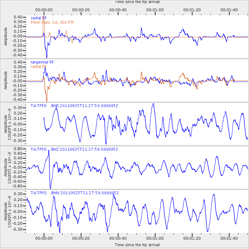
TPFO Pinon Flats, CA, USA - Earthquake Result Viewer
*The percent match for this event was below the threshold and hence no stack was calculated.
| Earthquake location: |
South Of Fiji Islands |
| Earthquake latitude/longitude: |
-24.5/179.4 |
| Earthquake time(UTC): |
2011/06/25 (176) 21:16:55 GMT |
| Earthquake Depth: |
528 km |
| Earthquake Magnitude: |
5.5 MB, 5.6 MW, 5.6 MW |
| Earthquake Catalog/Contributor: |
WHDF/NEIC |
|
| Network: |
TA USArray Transportable Network (new EarthScope stations) |
| Station: |
TPFO Pinon Flats, CA, USA |
| Lat/Lon: |
33.61 N/116.45 W |
| Elevation: |
1275 m |
|
| Distance: |
84.0 deg |
| Az: |
49.053 deg |
| Baz: |
235.529 deg |
| Ray Param: |
$rayparam |
*The percent match for this event was below the threshold and hence was not used in the summary stack. |
|
| Radial Match: |
72.138275 % |
| Radial Bump: |
400 |
| Transverse Match: |
48.050026 % |
| Transverse Bump: |
400 |
| SOD ConfigId: |
395004 |
| Insert Time: |
2011-12-08 04:37:33.088 +0000 |
| GWidth: |
2.5 |
| Max Bumps: |
400 |
| Tol: |
0.001 |
|
Signal To Noise
| Channel | StoN | STA | LTA |
| TA:TPFO: :BHZ:20110625T21:27:59.099995Z | 2.4969645 | 4.574125E-7 | 1.8318742E-7 |
| TA:TPFO: :BHN:20110625T21:27:59.099995Z | 0.9024121 | 1.2291338E-7 | 1.3620537E-7 |
| TA:TPFO: :BHE:20110625T21:27:59.099995Z | 1.2288237 | 1.6640605E-7 | 1.3541899E-7 |
| Arrivals |
| Ps | |
| PpPs | |
| PsPs/PpSs | |


