You are here: Home > Network List > UW - Pacific Northwest Regional Seismic Network Stations List
> Station FISH Seaside, OR, USA > Earthquake Result Viewer
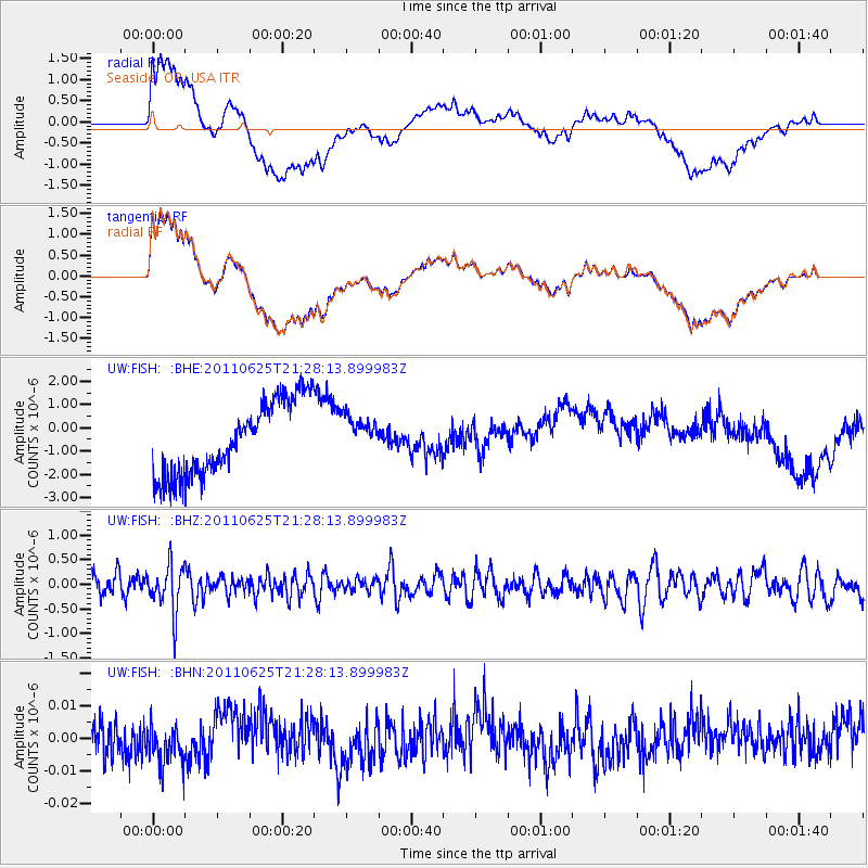
FISH Seaside, OR, USA - Earthquake Result Viewer
*The percent match for this event was below the threshold and hence no stack was calculated.
| Earthquake location: |
South Of Fiji Islands |
| Earthquake latitude/longitude: |
-24.5/179.4 |
| Earthquake time(UTC): |
2011/06/25 (176) 21:16:55 GMT |
| Earthquake Depth: |
528 km |
| Earthquake Magnitude: |
5.5 MB, 5.6 MW, 5.6 MW |
| Earthquake Catalog/Contributor: |
WHDF/NEIC |
|
| Network: |
UW Pacific Northwest Regional Seismic Network |
| Station: |
FISH Seaside, OR, USA |
| Lat/Lon: |
45.93 N/123.56 W |
| Elevation: |
325 m |
|
| Distance: |
87.1 deg |
| Az: |
35.912 deg |
| Baz: |
229.955 deg |
| Ray Param: |
$rayparam |
*The percent match for this event was below the threshold and hence was not used in the summary stack. |
|
| Radial Match: |
57.83092 % |
| Radial Bump: |
400 |
| Transverse Match: |
57.797295 % |
| Transverse Bump: |
400 |
| SOD ConfigId: |
395004 |
| Insert Time: |
2011-12-08 04:38:42.158 +0000 |
| GWidth: |
2.5 |
| Max Bumps: |
400 |
| Tol: |
0.001 |
|
Signal To Noise
| Channel | StoN | STA | LTA |
| UW:FISH: :BHZ:20110625T21:28:13.899983Z | 2.6125033 | 4.7489092E-7 | 1.817762E-7 |
| UW:FISH: :BHN:20110625T21:28:13.899983Z | 1.0705032 | 6.048998E-9 | 5.650612E-9 |
| UW:FISH: :BHE:20110625T21:28:13.899983Z | 0.50881 | 7.9756006E-7 | 1.5675009E-6 |
| Arrivals |
| Ps | |
| PpPs | |
| PsPs/PpSs | |


