You are here: Home > Network List > G - GEOSCOPE Stations List
> Station ATD Arta Cave, Djibouti > Earthquake Result Viewer
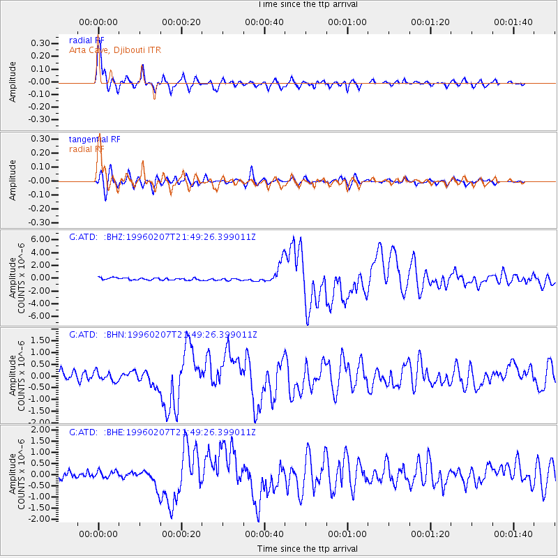
ATD Arta Cave, Djibouti - Earthquake Result Viewer

| Earthquake location: |
Kuril Islands |
| Earthquake latitude/longitude: |
45.3/149.9 |
| Earthquake time(UTC): |
1996/02/07 (038) 21:36:45 GMT |
| Earthquake Depth: |
33 km |
| Earthquake Magnitude: |
6.3 MB, 7.0 MS, 7.2 UNKNOWN, 7.1 MW |
| Earthquake Catalog/Contributor: |
WHDF/NEIC |
|
| Network: |
G GEOSCOPE |
| Station: |
ATD Arta Cave, Djibouti |
| Lat/Lon: |
11.53 N/42.85 E |
| Elevation: |
610 m |
|
| Distance: |
93.6 deg |
| Az: |
290.156 deg |
| Baz: |
42.514 deg |
| Ray Param: |
0.041225217 |
| Estimated Moho Depth: |
64.25 km |
| Estimated Crust Vp/Vs: |
2.05 |
| Assumed Crust Vp: |
6.375 km/s |
| Estimated Crust Vs: |
3.106 km/s |
| Estimated Crust Poisson's Ratio: |
0.34 |
|
| Radial Match: |
96.51481 % |
| Radial Bump: |
400 |
| Transverse Match: |
82.66942 % |
| Transverse Bump: |
400 |
| SOD ConfigId: |
6273 |
| Insert Time: |
2010-02-26 21:28:03.277 +0000 |
| GWidth: |
2.5 |
| Max Bumps: |
400 |
| Tol: |
0.001 |
|
Signal To Noise
| Channel | StoN | STA | LTA |
| G:ATD: :BHN:19960207T21:49:26.399011Z | 1.096926 | 2.0476115E-7 | 1.8666815E-7 |
| G:ATD: :BHE:19960207T21:49:26.399011Z | 0.66162795 | 1.4883612E-7 | 2.2495439E-7 |
| G:ATD: :BHZ:19960207T21:49:26.399011Z | 1.0803678 | 1.8317128E-7 | 1.695453E-7 |
| Arrivals |
| Ps | 11 SECOND |
| PpPs | 30 SECOND |
| PsPs/PpSs | 41 SECOND |


