You are here: Home > Network List > TA - USArray Transportable Network (new EarthScope stations) Stations List
> Station D36A Goodland, MN, USA > Earthquake Result Viewer
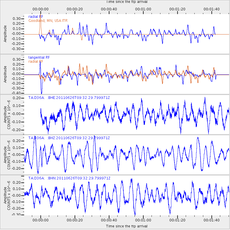
D36A Goodland, MN, USA - Earthquake Result Viewer
*The percent match for this event was below the threshold and hence no stack was calculated.
| Earthquake location: |
Mariana Islands |
| Earthquake latitude/longitude: |
18.9/146.3 |
| Earthquake time(UTC): |
2011/06/26 (177) 09:19:48 GMT |
| Earthquake Depth: |
99 km |
| Earthquake Magnitude: |
5.6 MB, 5.5 MW, 5.5 MW |
| Earthquake Catalog/Contributor: |
WHDF/NEIC |
|
| Network: |
TA USArray Transportable Network (new EarthScope stations) |
| Station: |
D36A Goodland, MN, USA |
| Lat/Lon: |
47.18 N/93.16 W |
| Elevation: |
434 m |
|
| Distance: |
95.4 deg |
| Az: |
36.16 deg |
| Baz: |
305.012 deg |
| Ray Param: |
$rayparam |
*The percent match for this event was below the threshold and hence was not used in the summary stack. |
|
| Radial Match: |
51.72687 % |
| Radial Bump: |
400 |
| Transverse Match: |
52.449837 % |
| Transverse Bump: |
400 |
| SOD ConfigId: |
395004 |
| Insert Time: |
2011-12-08 04:58:48.206 +0000 |
| GWidth: |
2.5 |
| Max Bumps: |
400 |
| Tol: |
0.001 |
|
Signal To Noise
| Channel | StoN | STA | LTA |
| TA:D36A: :BHZ:20110626T09:32:29.799971Z | 0.87422884 | 9.285857E-8 | 1.0621769E-7 |
| TA:D36A: :BHN:20110626T09:32:29.799971Z | 0.7153728 | 7.068335E-8 | 9.880632E-8 |
| TA:D36A: :BHE:20110626T09:32:29.799971Z | 0.53784025 | 4.6758892E-8 | 8.693826E-8 |
| Arrivals |
| Ps | |
| PpPs | |
| PsPs/PpSs | |


