You are here: Home > Network List > TA - USArray Transportable Network (new EarthScope stations) Stations List
> Station F31A Hecla, SD, USA > Earthquake Result Viewer
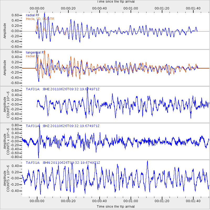
F31A Hecla, SD, USA - Earthquake Result Viewer
*The percent match for this event was below the threshold and hence no stack was calculated.
| Earthquake location: |
Mariana Islands |
| Earthquake latitude/longitude: |
18.9/146.3 |
| Earthquake time(UTC): |
2011/06/26 (177) 09:19:48 GMT |
| Earthquake Depth: |
99 km |
| Earthquake Magnitude: |
5.6 MB, 5.5 MW, 5.5 MW |
| Earthquake Catalog/Contributor: |
WHDF/NEIC |
|
| Network: |
TA USArray Transportable Network (new EarthScope stations) |
| Station: |
F31A Hecla, SD, USA |
| Lat/Lon: |
45.86 N/98.25 W |
| Elevation: |
412 m |
|
| Distance: |
93.1 deg |
| Az: |
39.187 deg |
| Baz: |
301.106 deg |
| Ray Param: |
$rayparam |
*The percent match for this event was below the threshold and hence was not used in the summary stack. |
|
| Radial Match: |
61.580345 % |
| Radial Bump: |
400 |
| Transverse Match: |
63.99089 % |
| Transverse Bump: |
400 |
| SOD ConfigId: |
395004 |
| Insert Time: |
2011-12-08 04:59:02.397 +0000 |
| GWidth: |
2.5 |
| Max Bumps: |
400 |
| Tol: |
0.001 |
|
Signal To Noise
| Channel | StoN | STA | LTA |
| TA:F31A: :BHZ:20110626T09:32:19.674971Z | 3.29616 | 3.296167E-7 | 1.0000022E-7 |
| TA:F31A: :BHN:20110626T09:32:19.674971Z | 1.7336348 | 2.1903578E-7 | 1.2634483E-7 |
| TA:F31A: :BHE:20110626T09:32:19.674971Z | 1.7372794 | 3.0001394E-7 | 1.7269183E-7 |
| Arrivals |
| Ps | |
| PpPs | |
| PsPs/PpSs | |


