You are here: Home > Network List > G - GEOSCOPE Stations List
> Station ATD Arta Cave, Djibouti > Earthquake Result Viewer
ATD Arta Cave, Djibouti - Earthquake Result Viewer
| Earthquake location: |
Samar, Philippines |
| Earthquake latitude/longitude: |
12.6/125.2 |
| Earthquake time(UTC): |
1996/06/11 (163) 18:22:55 GMT |
| Earthquake Depth: |
33 km |
| Earthquake Magnitude: |
6.0 MB, 7.0 MS, 7.2 UNKNOWN, 7.1 MW |
| Earthquake Catalog/Contributor: |
WHDF/NEIC |
|
| Network: |
G GEOSCOPE |
| Station: |
ATD Arta Cave, Djibouti |
| Lat/Lon: |
11.53 N/42.85 E |
| Elevation: |
610 m |
|
| Distance: |
80.1 deg |
| Az: |
279.664 deg |
| Baz: |
79.076 deg |
| Ray Param: |
0.04843233 |
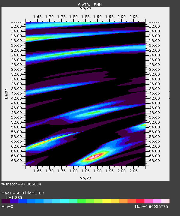
| Estimated Moho Depth: |
66.0 km |
| Estimated Crust Vp/Vs: |
1.88 |
| Assumed Crust Vp: |
6.375 km/s |
| Estimated Crust Vs: |
3.382 km/s |
| Estimated Crust Poisson's Ratio: |
0.30 |
|
| Radial Match: |
97.065834 % |
| Radial Bump: |
352 |
| Transverse Match: |
83.92706 % |
| Transverse Bump: |
400 |
| SOD ConfigId: |
6273 |
| Insert Time: |
2010-02-26 21:28:19.705 +0000 |
| GWidth: |
2.5 |
| Max Bumps: |
400 |
| Tol: |
0.001 |
|
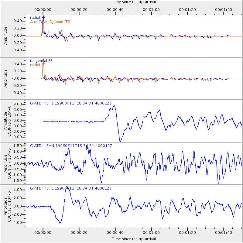
Signal To Noise
| Channel | StoN | STA | LTA |
| G:ATD: :BHN:19960611T18:34:31.400012Z | 0.94932646 | 1.729888E-7 | 1.8222268E-7 |
| G:ATD: :BHE:19960611T18:34:31.400012Z | 1.3223584 | 2.10748E-7 | 1.5937283E-7 |
| G:ATD: :BHZ:19960611T18:34:31.400012Z | 3.091529 | 4.2460596E-7 | 1.3734497E-7 |
| Arrivals |
| Ps | 9.4 SECOND |
| PpPs | 29 SECOND |
| PsPs/PpSs | 39 SECOND |


