You are here: Home > Network List > UW - Pacific Northwest Regional Seismic Network Stations List
> Station MRBL Marblemount, WA, USA > Earthquake Result Viewer
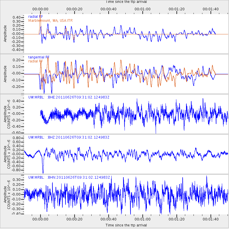
MRBL Marblemount, WA, USA - Earthquake Result Viewer
*The percent match for this event was below the threshold and hence no stack was calculated.
| Earthquake location: |
Mariana Islands |
| Earthquake latitude/longitude: |
18.9/146.3 |
| Earthquake time(UTC): |
2011/06/26 (177) 09:19:48 GMT |
| Earthquake Depth: |
99 km |
| Earthquake Magnitude: |
5.6 MB, 5.5 MW, 5.5 MW |
| Earthquake Catalog/Contributor: |
WHDF/NEIC |
|
| Network: |
UW Pacific Northwest Regional Seismic Network |
| Station: |
MRBL Marblemount, WA, USA |
| Lat/Lon: |
48.52 N/121.48 W |
| Elevation: |
75 m |
|
| Distance: |
77.6 deg |
| Az: |
42.871 deg |
| Baz: |
284.305 deg |
| Ray Param: |
$rayparam |
*The percent match for this event was below the threshold and hence was not used in the summary stack. |
|
| Radial Match: |
68.864655 % |
| Radial Bump: |
400 |
| Transverse Match: |
58.690426 % |
| Transverse Bump: |
400 |
| SOD ConfigId: |
395004 |
| Insert Time: |
2011-12-08 05:02:11.783 +0000 |
| GWidth: |
2.5 |
| Max Bumps: |
400 |
| Tol: |
0.001 |
|
Signal To Noise
| Channel | StoN | STA | LTA |
| UW:MRBL: :BHZ:20110626T09:31:02.124983Z | 2.5129237 | 3.080304E-7 | 1.2257848E-7 |
| UW:MRBL: :BHN:20110626T09:31:02.124983Z | 1.1786971 | 1.14483946E-7 | 9.712753E-8 |
| UW:MRBL: :BHE:20110626T09:31:02.124983Z | 1.5487994 | 1.7311812E-7 | 1.1177569E-7 |
| Arrivals |
| Ps | |
| PpPs | |
| PsPs/PpSs | |


